IMAGES TAKEN NEAR TO
Maple Gardens, BRIDPORT, DT6 4DP
Introduction
This page details the photographs taken nearby to Maple Gardens, DT6 4DP by members of the Geograph project.
The Geograph project started in 2005 with the aim of publishing, organising and preserving representative images for every square kilometre of Great Britain, Ireland and the Isle of Man.

There are currently over 7.5m images from over14,400 individuals and you can help contribute to the project by visiting https://www.geograph.org.uk
Image Map
Images are licensed for reuse under creativecommons.org/licenses/by-sa/2.0
Notes
- Clicking on the map will re-center to the selected point.
- The higher the marker number, the further away the image location is from the centre of the postcode.
Image Listing (168 Images Found)
Images are licensed for reuse under creativecommons.org/licenses/by-sa/2.0
Image
Details
Distance
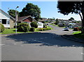
1

Up Maple Gardens, Bridport
The road named Maple Gardens ascends towards Pasture Way.
Image: © Jaggery
Taken: 25 Aug 2017
0.05 miles
2
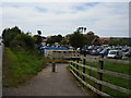
Footpath from Sea Road South
A pedestrian route to Morrisons Supermarket.
Their recycling centre is in the foreground.
Image: © Anthony Vosper
Taken: 11 Aug 2012
0.07 miles
3
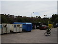
Recycling at Morrisons, Bridport
A well equipped corner of a busy supermarket car park.
Image: © Anthony Vosper
Taken: 11 Aug 2012
0.08 miles
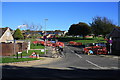
4
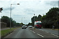
A35 Sea Road South, Bridport
Avoiding the town centre.
Image: © Robin Webster
Taken: 18 Jul 2019
0.09 miles
5
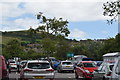
View across Morrisons' car park
Looking east towards Hyde Hill.
Image: © Trevor Harris
Taken: 4 Aug 2017
0.09 miles
6
Pasture Way, Bridport
On the east side of the A35 Sea Road South.
Image: © Jaggery
Taken: 25 Aug 2017
0.10 miles
7
Maple Gardens
View of Maple Gardesn from the A35. Gas work in progress.
Image: © John Stephen
Taken: 14 Oct 2012
0.10 miles
8

Footpath off Sea Road South, Bridport
This will take you over Askers Meadow Nature Reserve and on over the River Brit.
Image: © Anthony Vosper
Taken: 11 Aug 2012
0.10 miles
9
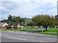
Housing Estate Bridport.
The junction of Pasture Way with the A35 Sea Rd South.
Image: © Nigel Mykura
Taken: 18 Sep 2008
0.10 miles
10
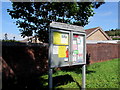
Bothenhampton and Walditch Parish Council noticeboard, Bridport
Alongside a path on the north side of Pasture Way, near the A35 Sea Road South junction.
Image: © Jaggery
Taken: 25 Aug 2017
0.11 miles