IMAGES TAKEN NEAR TO
Jessopp Avenue, BRIDPORT, DT6 4AT
Introduction
This page details the photographs taken nearby to Jessopp Avenue, DT6 4AT by members of the Geograph project.
The Geograph project started in 2005 with the aim of publishing, organising and preserving representative images for every square kilometre of Great Britain, Ireland and the Isle of Man.

There are currently over 7.5m images from over14,400 individuals and you can help contribute to the project by visiting https://www.geograph.org.uk
Image Map
Images are licensed for reuse under creativecommons.org/licenses/by-sa/2.0
Notes
- Clicking on the map will re-center to the selected point.
- The higher the marker number, the further away the image location is from the centre of the postcode.
Image Listing (60 Images Found)
Images are licensed for reuse under creativecommons.org/licenses/by-sa/2.0
Image
Details
Distance
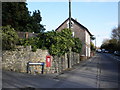
1

Bradpole: seat and postbox № DT6 34, Jessopp Avenue
A dual-purpose piece of street furniture in Jessopp Avenue, combining a George V-reign postbox set into the back of a bench which is presumably considerably younger, going by the housing in this street. The box is emptied finally at 4pm on weekdays and at noon on Saturday.
Image: © Chris Downer
Taken: 20 Jun 2009
0.10 miles
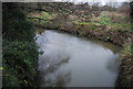
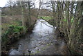
3
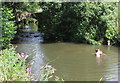
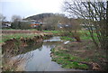
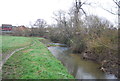
Boys Playing in the River Asker
Rather murky swimming water just downstream of the footbridge that carries the path from St Andrews Road to Jessopp Avenue.
Image: © Nigel Mykura
Taken: 3 Aug 2016
0.12 miles
6
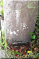
Old benchmark on gatepost of Pine Tree Cottage
The Ordnance Survey cut mark benchmark, levelled in 1850 and now partially buried, is described on the Bench Mark Database at http://www.bench-marks.org.uk/bm29070
Image: © Roger Templeman
Taken: 9 Jul 2011
0.14 miles
7
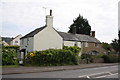
Lee Cottages, with Pine Tree Cottage on the left
The RHS gatepost has an Ordnance Survey cut mark benchmark Image dating from the 1849-1850 levelling of a survey line from Exeter to Southampton.
Image: © Roger Templeman
Taken: 9 Jul 2011
0.14 miles
9
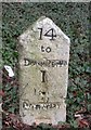
Old Milestone by the A35, East Road, Bridport
Carved stone post by the A35, in parish of BOTHENHAMPTON (WEST DORSET District), outskirts of Bridport, on the hill going down into Bridport, on South side of road, just past cemetery boundary wall. Dorset 1 (limestone), erected by the Harnham, Blandford & Dorchester turnpike trust in the 19th century.
Inscription reads:-
14
to
DORCHESTER
1
to
BRIDPORT
Milestone Society National ID: DO_BPDO01.
Image: © Mike Richards
Taken: 22 Aug 2002
0.14 miles