IMAGES TAKEN NEAR TO
Lee Lane, BRIDPORT, DT6 4AP
Introduction
This page details the photographs taken nearby to Lee Lane, DT6 4AP by members of the Geograph project.
The Geograph project started in 2005 with the aim of publishing, organising and preserving representative images for every square kilometre of Great Britain, Ireland and the Isle of Man.

There are currently over 7.5m images from over14,400 individuals and you can help contribute to the project by visiting https://www.geograph.org.uk
Image Map (Loading...)


Getting Data...Please wait
Leaflet Map data © OpenStreetMap
Images are licensed for reuse under creativecommons.org/licenses/by-sa/2.0
Notes
- Clicking on the map will re-center to the selected point.
- The higher the marker number, the further away the image location is from the centre of the postcode.
Image Listing (70 Images Found)
Images are licensed for reuse under creativecommons.org/licenses/by-sa/2.0
Image
Details
Distance
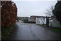
7
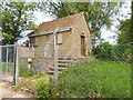
Sewage Pumping Station
This small building stands in Lee Lane, Bradpole, adjacent to the River Asker. It is operated by Wessex Water.
Image: © mike smith
Taken: 30 Apr 2011
0.05 miles