IMAGES TAKEN NEAR TO
Melplash, BRIDPORT, DT6 3UQ
Introduction
This page details the photographs taken nearby to DT6 3UQ by members of the Geograph project.
The Geograph project started in 2005 with the aim of publishing, organising and preserving representative images for every square kilometre of Great Britain, Ireland and the Isle of Man.

There are currently over 7.5m images from over14,400 individuals and you can help contribute to the project by visiting https://www.geograph.org.uk
Image Map (Loading...)


Getting Data...Please wait
Leaflet Map data © OpenStreetMap
Images are licensed for reuse under creativecommons.org/licenses/by-sa/2.0
Notes
- Clicking on the map will re-center to the selected point.
- The higher the marker number, the further away the image location is from the centre of the postcode.
Image Listing (12 Images Found)
Images are licensed for reuse under creativecommons.org/licenses/by-sa/2.0
Image
Details
Distance
1
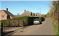
Twinways Lane, Melplash
Modern houses along the back lane from the southeast.
Image: © Derek Harper
Taken: 13 Mar 2017
0.05 miles
2
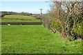
Field, Melplash
Looking almost along a northing gridline, which is actually about three metres to the left of the camera, from Twinhays Lane. The fence on the far side of the field borders the A3066.
Image: © Derek Harper
Taken: 13 Mar 2017
0.06 miles
3
Twinways Lane, Melplash and temporary gate screen
Image: © David Smith
Taken: 26 Aug 2020
0.07 miles
4

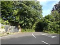
Cottage at Melplash
The A3066 entering the northern part of the village. White Cottage is at the corner of Twinways Lane.
Image: © Derek Harper
Taken: 13 Mar 2017
0.09 miles
5
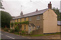
Cottages in Melplash
Laurel Cottage, Stoneybroke and Ravenshoe, in order away from the camera.
Image: © Ian Capper
Taken: 18 Jul 2008
0.16 miles
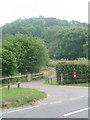
6

Outskirts of Melplash
Viewed from Twinways Lane, with the tower of Christ Church visible (see Image).
Image: © Ian Capper
Taken: 14 Jul 2008
0.18 miles
7
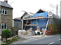
Building Renovation
These barns appeared to have been almost completely rebuilt. It is uncertain if they are being converted to living accommodation or not. Much of the old material such as bricks and stonework had been stored on the scaffolding ready for reuse.
Image: © Nigel Mykura
Taken: 4 Jun 2012
0.18 miles
8
Melplash: postbox № DT6 61
A small postbox serving northern outlying Melplash, emptied finally at 4pm on weekdays and at 10am on Saturdays.
Image: © Chris Downer
Taken: 2 Jul 2009
0.19 miles

10
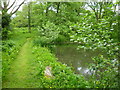
Footpath through wetland area, Melplash Court
Image: © Maurice D Budden
Taken: 7 Jun 2013
0.21 miles