IMAGES TAKEN NEAR TO
Powerstock, BRIDPORT, DT6 3SZ
Introduction
This page details the photographs taken nearby to DT6 3SZ by members of the Geograph project.
The Geograph project started in 2005 with the aim of publishing, organising and preserving representative images for every square kilometre of Great Britain, Ireland and the Isle of Man.

There are currently over 7.5m images from over14,400 individuals and you can help contribute to the project by visiting https://www.geograph.org.uk
Image Map (Loading...)


Getting Data...Please wait
Leaflet Map data © OpenStreetMap
Images are licensed for reuse under creativecommons.org/licenses/by-sa/2.0
Notes
- Clicking on the map will re-center to the selected point.
- The higher the marker number, the further away the image location is from the centre of the postcode.
Image Listing (185 Images Found)
Images are licensed for reuse under creativecommons.org/licenses/by-sa/2.0
Image
Details
Distance
2
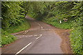
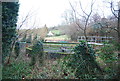
Who has priority?
Whichever direction one arrives at this junction (the right hand entry is only a track) would seem to require giving way - a bit like a roundabout without the roundabout!
Image: © Ian Capper
Taken: 15 Jul 2008
0.04 miles
4
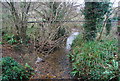
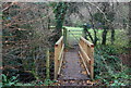
Small stream near Powerstock
A small tributary of the Mangerton River.
Image: © N Chadwick
Taken: 31 Dec 2011
0.05 miles
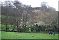
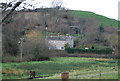
5
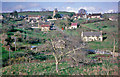
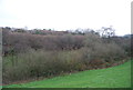
Powerstock: general view from south
View from Merriott in Springtime.
Image: © Ben Brooksbank
Taken: 23 Apr 1963
0.05 miles