IMAGES TAKEN NEAR TO
West Milton, BRIDPORT, DT6 3SW
Introduction
This page details the photographs taken nearby to DT6 3SW by members of the Geograph project.
The Geograph project started in 2005 with the aim of publishing, organising and preserving representative images for every square kilometre of Great Britain, Ireland and the Isle of Man.

There are currently over 7.5m images from over14,400 individuals and you can help contribute to the project by visiting https://www.geograph.org.uk
Image Map
Images are licensed for reuse under creativecommons.org/licenses/by-sa/2.0
Notes
- Clicking on the map will re-center to the selected point.
- The higher the marker number, the further away the image location is from the centre of the postcode.
Image Listing (10 Images Found)
Images are licensed for reuse under creativecommons.org/licenses/by-sa/2.0
Image
Details
Distance
1
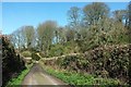
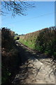
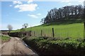
Lane past William's Wood
From the same spot as Image], looking right. 40 metres away on the left is a sign indicating the start of bridleway W13 35. The lane then enters a cutting between Presswood Copse and William's Wood. To the left is a glimpse of the roof of Spinney Kot.
Image: © Derek Harper
Taken: 13 Mar 2017
0.02 miles
2
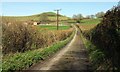
Lane past Corfe Farm
Corfe Farm is on the left. Above it rises Round Knoll.
Image: © Derek Harper
Taken: 13 Mar 2017
0.05 miles
3
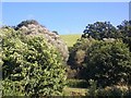
Presswood Copse
The wood seen from the lane between West Milton and Loders.
Image: © Derek Harper
Taken: 13 Mar 2017
0.12 miles
4
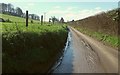
Lane to West Milton
From the junction where Image] was taken.
Image: © Derek Harper
Taken: 13 Mar 2017
0.14 miles
5
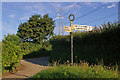
Lane junction north of Loders
With the map reference conveniently painted on to the signpost.
Image: © Ian Capper
Taken: 16 Jul 2008
0.18 miles
6
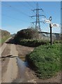
Junction north of Loders
Ahead is Yellow Lane, leading to Mappercombe.
Image: © Derek Harper
Taken: 13 Mar 2017
0.18 miles
7
Yellow Lane
From the junction where Image] was taken, looking towards Bradpole. Up on the left is Waddon Copse.
Image: © Derek Harper
Taken: 13 Mar 2017
0.19 miles
8
Waddon Lane
From the junction shown in Image], with Symes's Hill Copse up on the right.
Image: © Derek Harper
Taken: 13 Mar 2017
0.20 miles
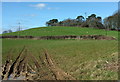
9
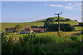
Corfe Farm and Round Knoll
Round Knoll justifies its name from all directions - see for example Image for view from north.
Image: © Ian Capper
Taken: 16 Jul 2008
0.21 miles