IMAGES TAKEN NEAR TO
St. Michaels Lane, BRIDPORT, DT6 3RD
Introduction
This page details the photographs taken nearby to St. Michaels Lane, DT6 3RD by members of the Geograph project.
The Geograph project started in 2005 with the aim of publishing, organising and preserving representative images for every square kilometre of Great Britain, Ireland and the Isle of Man.

There are currently over 7.5m images from over14,400 individuals and you can help contribute to the project by visiting https://www.geograph.org.uk
Image Map
Images are licensed for reuse under creativecommons.org/licenses/by-sa/2.0
Notes
- Clicking on the map will re-center to the selected point.
- The higher the marker number, the further away the image location is from the centre of the postcode.
Image Listing (711 Images Found)
Images are licensed for reuse under creativecommons.org/licenses/by-sa/2.0
Image
Details
Distance
1
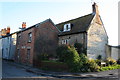
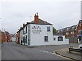
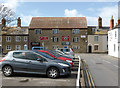
26, 28 and 28a St Michael's Lane
18thC Grade 2 listed stone houses at 26 (at the end of terrace) and 28 St Michaels Lane. No 28 has at some point in the 19thC been provided with an unlisted brick extension and was "The Phoenix" public house having since been converted into two flats 28 a and b.
Image: © John Stephen
Taken: 31 Aug 2015
0.00 miles
2
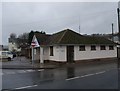
Public conveniences at Bridport bus station
Image: © Tim Heaton
Taken: 28 Jan 2013
0.01 miles
3
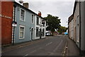
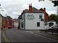
St Michael's Lane, Bridport
Looking south past the Hope and Anchor. Not for sale, that's next door.
Image: © John Stephen
Taken: 16 Aug 2014
0.01 miles
4
Victorian terrace, St Michael's Lane, Bridport
Note the end of the back alleyway between the blocks.
Image: © Bill Harrison
Taken: 9 Jul 2016
0.02 miles
5
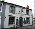
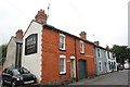
The Hope and Anchor, St Michael's Lane, Bridport
Looks like a classic back-street pub and Grade-II listed (ref: 1227778), https://www.britishlistedbuildings.co.uk/101227778-hope-and-anchor-public-house-bridport#.Whx_piZLGAg .
Image: © Bill Harrison
Taken: 9 Jul 2016
0.02 miles
6
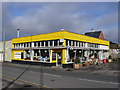
Cafe Royal Bridport
This cafe seems to be left over from another age. It is slightly dog eared but serves good coffee and cakes. It is right next to the bus station and is in a row of dilapidated shops most of which are boarded up. It won't be too long before developers change the scenery.
Image: © Nigel Mykura
Taken: 30 Oct 2011
0.02 miles
7
Bridport, Hope & Anchor
Free house in the old town centre; Long bar at back, drinking areas left, front & right; darts. When I was there, an excellent blues band was playing. Cask ales on offer at my visit: Butcombe Haka, Sharps Doom Bar, St Austells Trelawny. For some customer comments, see http://www.beerintheevening.com/pubs/s/21/21749/Hope_and_Anchor/Bridport
Image: © Mike Faherty
Taken: 22 Sep 2013
0.02 miles
9
Old warehouse, Bridport
This early 19th century warehouse on St Michael's Lane stands at the head of a series of open and covered rope/twine walks and was possibly converted from a pair of cottages. It is now in multiple occupancy.
Image: © Chris Allen
Taken: 31 Mar 2015
0.02 miles
10
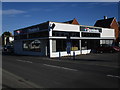
Bridport's Domino's, former Caf? Royale
This was the Café Royale and had windows set leaning up and out at an angle to the vertical, which were considered to be an unusual example of mid 20thC architecture and an asset to the town. When the building was changed to a Domino's earlier this year, the windows were replaced with vertical ones against the planning approval agreements for change of use. After a stand-off with the planners, the owners/franchisees got away with the change retrospectively using health and safety as an argument. Funny that nobody had thought of any safety objections previously during the many years since the originals were installed at an angle. See also Image and Image
Image: © John Stephen
Taken: 2 Nov 2016
0.03 miles