IMAGES TAKEN NEAR TO
King Street, BRIDPORT, DT6 3QD
Introduction
This page details the photographs taken nearby to King Street, DT6 3QD by members of the Geograph project.
The Geograph project started in 2005 with the aim of publishing, organising and preserving representative images for every square kilometre of Great Britain, Ireland and the Isle of Man.

There are currently over 7.5m images from over14,400 individuals and you can help contribute to the project by visiting https://www.geograph.org.uk
Image Map (Loading...)


Getting Data...Please wait
Leaflet Map data © OpenStreetMap
Images are licensed for reuse under creativecommons.org/licenses/by-sa/2.0
Notes
- Clicking on the map will re-center to the selected point.
- The higher the marker number, the further away the image location is from the centre of the postcode.
Image Listing (665 Images Found)
Images are licensed for reuse under creativecommons.org/licenses/by-sa/2.0
Image
Details
Distance
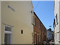
1
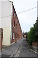
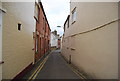
King Street
Looking up King Street from Folly Mill Lane.
Image: © John Stephen
Taken: 21 Oct 2012
0.00 miles
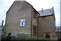
3
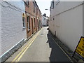
King Street, Bridport
Viewed from East Street opposite Barrack Street.
Double yellow lines on both sides of narrow King Street indicate no parking at any time.
Image: © Jaggery
Taken: 25 Aug 2017
0.02 miles
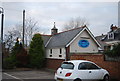
7
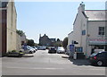
East Street Short Stay Pay & Display Car Park, Bridport
On the south side of the B3162 East Street.
Image: © Jaggery
Taken: 25 Aug 2017
0.02 miles
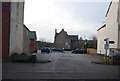
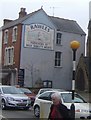
10
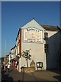
Advert for a butcher in Bridport
It is still a butcher's shop.
Image: © David Smith
Taken: 25 Jun 2010
0.03 miles