IMAGES TAKEN NEAR TO
Village Road, BRIDPORT, DT6 3ES
Introduction
This page details the photographs taken nearby to Village Road, DT6 3ES by members of the Geograph project.
The Geograph project started in 2005 with the aim of publishing, organising and preserving representative images for every square kilometre of Great Britain, Ireland and the Isle of Man.

There are currently over 7.5m images from over14,400 individuals and you can help contribute to the project by visiting https://www.geograph.org.uk
Image Map
Images are licensed for reuse under creativecommons.org/licenses/by-sa/2.0
Notes
- Clicking on the map will re-center to the selected point.
- The higher the marker number, the further away the image location is from the centre of the postcode.
Image Listing (68 Images Found)
Images are licensed for reuse under creativecommons.org/licenses/by-sa/2.0
Image
Details
Distance
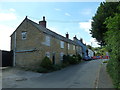
1

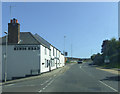
Bradpole: phone box on the corner of King William Head
A motorcyclist makes his way along the A3066 out of town towards Beaminster as we look at the red phone box at the junction with this curiously named side-road.
Image: © Chris Downer
Taken: 6 Apr 2015
0.04 miles
2
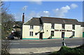
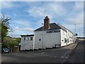
The King's Head, Bradpole
This is a large pub on the A3066 road, and the only one in Bradpole. The village centre is a little way down the appropriately named Village Road which can be seen at the left of the picture.
Image: © Stephen Williams
Taken: 6 Mar 2007
0.04 miles
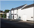
7
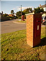
Bradpole: postbox № DT6 91 and phone, Court Close
Looking across the junction of the main Beaminster Road with Court Close, just to late to see the Elizabeth II-reign postbox in direct sunlight. It is emptied finally at 4:45pm on weekdays and at noon on Saturdays.
Image: © Chris Downer
Taken: 12 Sep 2009
0.06 miles
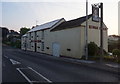
8
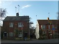
Houses separated by Dodham's Lane
Dodham's Lane is no through road to vehicles, although bicycles can use the road. It is used as pedestrian access to Sir John Colfox School. The semi-detached houses on the left are "Yew Cottage"
Image: © David Smith
Taken: 27 Dec 2013
0.06 miles
9
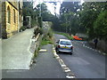
Road and footpath junctions near the Church
The raised footpath leads to Holy Trinity Church from Village Street. The right turn is Middle Street.
Image: © Roger Templeman
Taken: 22 Sep 2010
0.12 miles