IMAGES TAKEN NEAR TO
St. Andrews Road, BRIDPORT, DT6 3BN
Introduction
This page details the photographs taken nearby to St. Andrews Road, DT6 3BN by members of the Geograph project.
The Geograph project started in 2005 with the aim of publishing, organising and preserving representative images for every square kilometre of Great Britain, Ireland and the Isle of Man.

There are currently over 7.5m images from over14,400 individuals and you can help contribute to the project by visiting https://www.geograph.org.uk
Image Map (Loading...)


Getting Data...Please wait
Leaflet Map data © OpenStreetMap
Images are licensed for reuse under creativecommons.org/licenses/by-sa/2.0
Notes
- Clicking on the map will re-center to the selected point.
- The higher the marker number, the further away the image location is from the centre of the postcode.
Image Listing (51 Images Found)
Images are licensed for reuse under creativecommons.org/licenses/by-sa/2.0
Image
Details
Distance
1

#128 St Andrews Road
Local Fax, photocopying service. There is an OS benchmark Image on the mustard-coloured outbuilding.
Image: © Roger Templeman
Taken: 20 Nov 2011
0.01 miles
2

Benchmark on #128 St Andrews Road
Ordnance Survey cut mark benchmark described on the Bench Mark Database at http://www.bench-marks.org.uk/bm25020
Image: © Roger Templeman
Taken: 20 Sep 2010
0.01 miles
3

Co-Operative supermarket, Sea Road North,
Image: © David Smith
Taken: 27 Dec 2013
0.01 miles
4
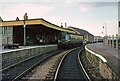
Bridport station, 1964
This was the terminus for passengers following the closure of West Bay Station in 1930, although freight services continued until 1965. The line survived the immediate aftermath of the Beeching Report, but closed in 1975.
This view shows the service being worked by a single car diesel unit, known affectionately as 'Bubble cars'. This type was found on many of the branch lines of the west of England, and eventually became the longest-serving of the British Railways diesel units of its era. The signal at the far end of the platform is of interest, as it is a Southern Railway type, with upper quadrant, despite this having been a Great Western Railway branch. It would have been replaced during the period when the branch fell within the Southern Region of British Railways.
The station has disappeared without trace under road and industrial estate development.
Image: © Alan Murray-Rust
Taken: Unknown
0.03 miles

7
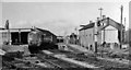
Bridport Station
View northward, towards Maiden Newton; ex-GWR semi-terminus of branch from Maiden Newton, with a DMU branch train (probably through from Weymouth) at the platforrm. The line in the foreground continued through East St. station to Bridport West Bay and had been open for goods until 3/12/62 although closed to passengers on 22/9/30. This station and the line from Maiden Newton survived until 5/5/75.
Image: © Ben Brooksbank
Taken: 22 Apr 1963
0.04 miles
8

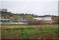
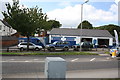
Central Motors, Sea Road North
Central Motors from the east side of Sea Road North.
Image: © John Stephen
Taken: 18 Aug 2014
0.05 miles
9
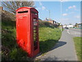
Bridport: telephone box on Beaminster Road
This red phone box could do with some tender loving care, with regards to the paintwork as well as the glazing. It stands on the acute corner of St. Andrew's Road, although the main course for today's motorist has been altered.
Image: © Chris Downer
Taken: 6 Apr 2015
0.06 miles
10
Central Motors, Sea Road North
Looking west across Sea Road North at Central Motors. This is the site of the Bridport Station stables. The road off to the left follows the line of the railway.
Image: © John Stephen
Taken: 18 Aug 2014
0.06 miles