IMAGES TAKEN NEAR TO
Alm Place, PORTLAND, DT5 2LT
Introduction
This page details the photographs taken nearby to Alm Place, DT5 2LT by members of the Geograph project.
The Geograph project started in 2005 with the aim of publishing, organising and preserving representative images for every square kilometre of Great Britain, Ireland and the Isle of Man.

There are currently over 7.5m images from over14,400 individuals and you can help contribute to the project by visiting https://www.geograph.org.uk
Image Map
Images are licensed for reuse under creativecommons.org/licenses/by-sa/2.0
Notes
- Clicking on the map will re-center to the selected point.
- The higher the marker number, the further away the image location is from the centre of the postcode.
Image Listing (107 Images Found)
Images are licensed for reuse under creativecommons.org/licenses/by-sa/2.0
Image
Details
Distance
1
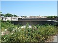
Former railway bridge, Weston
The cutting where the railway formerly ran has been filled with waste from quarries.
Image: © David Smith
Taken: 25 Jun 2010
0.07 miles
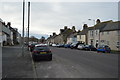
2

Delhi Lane, Easton, Portland, Dorset
Near the centre of the village.
Image: © Christine Matthews
Taken: 12 Aug 2010
0.10 miles
4
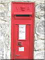
Victorian post box
Situated in Wakeham
Image: © Simon Palmer
Taken: 16 May 2009
0.11 miles
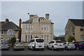
5

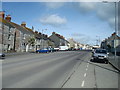
Main Street, Easton, Portland, Dorset
Colourful house really stands out beside its neighbours.
Image: © Christine Matthews
Taken: 12 Aug 2010
0.12 miles
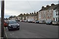
6
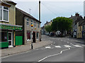
Easton, Portland
Looking from Easton Square into Straits.
Image: © Chris Gunns
Taken: 25 May 2009
0.12 miles
10
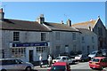
Pharmacy in a row of terraced buildings, Easton
Image: © David Smith
Taken: 25 Jun 2010
0.13 miles