IMAGES TAKEN NEAR TO
Martinscroft Road, PORTLAND, DT5 2JD
Introduction
This page details the photographs taken nearby to Martinscroft Road, DT5 2JD by members of the Geograph project.
The Geograph project started in 2005 with the aim of publishing, organising and preserving representative images for every square kilometre of Great Britain, Ireland and the Isle of Man.

There are currently over 7.5m images from over14,400 individuals and you can help contribute to the project by visiting https://www.geograph.org.uk
Image Map
Images are licensed for reuse under creativecommons.org/licenses/by-sa/2.0
Notes
- Clicking on the map will re-center to the selected point.
- The higher the marker number, the further away the image location is from the centre of the postcode.
Image Listing (70 Images Found)
Images are licensed for reuse under creativecommons.org/licenses/by-sa/2.0
Image
Details
Distance
1
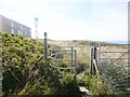
Weston, kissing gate
Kissing no longer possible, as the moving part has failed. Image in the distance.
Image: © Mike Faherty
Taken: 30 Aug 2014
0.03 miles
2
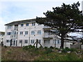
Not Sheltered Housing, Portland
This must be some of the most exposed housing in britain. This apartment block in Weston is less than 100m from the Blacknor cliff top on the west facing coast of Portland,taking the full force of sou'westerly gales
Image: © Nigel Mykura
Taken: 8 Mar 2008
0.03 miles
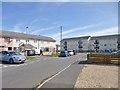
3
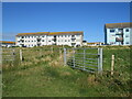
Path into a housing estate, Weston, Isle of Portland
A path leading into a housing estate in Weston, on the Isle of Portland.
Image: © Malc McDonald
Taken: 14 Aug 2021
0.04 miles
4
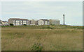
Housing at southwest corner of Weston, Portland
The site is bleak, the architecture uninspired.
Image: © Peter Facey
Taken: 12 Jul 2016
0.04 miles
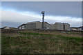
6
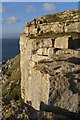
Weston, disused quarry workings
Overlooking Mutton Cove, a platform shown on old OS maps once to have been the site of a crane.
Image: © Mike Faherty
Taken: 30 Aug 2014
0.06 miles
7
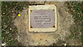
Memorial plaque at Blacknor
Near the top of the cliff and facing west. I have been unable to find more information about this. The cliffs here are used for rock climbing but the age of Geoff, 68, does not suggest a climbing accident. The plaque might be bronze; the fixing screws unfortunately are steel. The inscription reads:-
IN MEMORY OF
GEOFF
LOVING HUSBAND
DAD & GRANDAD
FOREVER LOVED
15/12/42 - 02/04/10
xxx
Image: © Peter Facey
Taken: 12 Jul 2016
0.06 miles
8
Weston, Grangecroft Road
Modern housing development.
Image: © Mike Faherty
Taken: 30 Aug 2014
0.06 miles
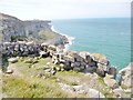
10
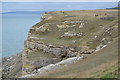
Cliffs above Mutton Cove
This view is from a large stone wall on the precipitous edge of an old quarry above Mutton Cove. The figure on the Portland Stone cliff gives an idea of scale. The landslides on the left are where the cliffs have collapsed over the Kimmeridge Clay.
Image: © Jim Champion
Taken: 31 Oct 2008
0.07 miles