IMAGES TAKEN NEAR TO
Southwell Street, PORTLAND, DT5 2EG
Introduction
This page details the photographs taken nearby to Southwell Street, DT5 2EG by members of the Geograph project.
The Geograph project started in 2005 with the aim of publishing, organising and preserving representative images for every square kilometre of Great Britain, Ireland and the Isle of Man.

There are currently over 7.5m images from over14,400 individuals and you can help contribute to the project by visiting https://www.geograph.org.uk
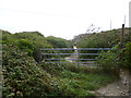
Image Map
Images are licensed for reuse under creativecommons.org/licenses/by-sa/2.0
Notes
- Clicking on the map will re-center to the selected point.
- The higher the marker number, the further away the image location is from the centre of the postcode.
Image Listing (109 Images Found)
Images are licensed for reuse under creativecommons.org/licenses/by-sa/2.0
Image
Details
Distance
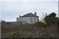
2
Southwell, Cheyne House
Not bearing a house name-sign, but old OS maps call it this. In a commanding position overlooking Freshwater Bay.
Image: © Mike Faherty
Taken: 25 Oct 2013
0.01 miles
3
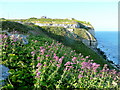
Valerian on the clifftop
Catching the last rays of evening sun to reach the east coast of Portland.
Image: © Jonathan Billinger
Taken: 19 May 2009
0.02 miles
4
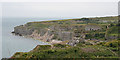
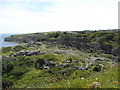
Freshwater Bay
The cliffs and landscape are shaped by the remains of stone quarries.
Image: © Anne Burgess
Taken: 4 Jul 2014
0.04 miles
5

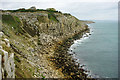
Cliffs at Freshwater Bay, Isle of Portland
The rugged coastline east of Weymouth can be seen in the distance.
Image: © Oliver Dixon
Taken: 25 Jun 2014
0.04 miles
6
Quarry at Freshwater Bay, Portland
Image: © Maurice D Budden
Taken: 26 Jun 2008
0.04 miles
7
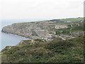
Freshwater Bay, Portland
Cheyne House is prominent. To its right is a hump which is the old Admiralty pump house, which once pumped fresh water up from a tank below fed by a natural spring issuing from the cliff. The bay was once more pronounced, but there was 19th century tipping of unwanted quarry debris into the sea forming the near slopes. The quarry concerned was inland, and a tramway was used to transport the rock to the tip.
Image: © Robin Webster
Taken: 26 Nov 2011
0.05 miles
8
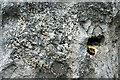
Thrombolite
According to Wikipedia thrombolites are clotted accretionary structures formed in shallow water by the trapping, binding, and cementation of sedimentary grains by biofilms of microorganisms, especially cyanobacteria. GPS for scale.
Image: © Anne Burgess
Taken: 5 Jul 2014
0.05 miles
9
Coastal quarries on Portland Bill
Image: © Sarah Charlesworth
Taken: 15 Oct 2010
0.05 miles
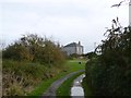
10
Southwell, gate
At the top of the path from Southwell Road to Freshwater Bay. It is not clear why the gate is padlocked; access to vehicles would be difficult!
Image: © Mike Faherty
Taken: 25 Oct 2013
0.05 miles