IMAGES TAKEN NEAR TO
Reap Lane, PORTLAND, DT5 2DW
Introduction
This page details the photographs taken nearby to Reap Lane, DT5 2DW by members of the Geograph project.
The Geograph project started in 2005 with the aim of publishing, organising and preserving representative images for every square kilometre of Great Britain, Ireland and the Isle of Man.

There are currently over 7.5m images from over14,400 individuals and you can help contribute to the project by visiting https://www.geograph.org.uk
Image Map
Images are licensed for reuse under creativecommons.org/licenses/by-sa/2.0
Notes
- Clicking on the map will re-center to the selected point.
- The higher the marker number, the further away the image location is from the centre of the postcode.
Image Listing (43 Images Found)
Images are licensed for reuse under creativecommons.org/licenses/by-sa/2.0
Image
Details
Distance
1
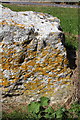
Benchmark on rock of Reap Lane wall
Ordnance Survey rivet benchmark described on the Bench Mark Database at http://www.bench-marks.org.uk/bm45538
Image: © Roger Templeman
Taken: 22 Sep 2012
0.03 miles
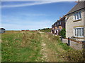
2
Rock wall separating Reap Lane from path past houses
There is an OS benchmark Image on the rock below the traffic priority road sign
Image: © Roger Templeman
Taken: 22 Sep 2012
0.03 miles
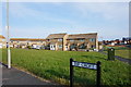
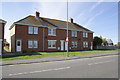
3
Houses on Cheyne Close and Reap Lane
From Rip Croft, Southwell, Portland.
Image: © Ian S
Taken: 29 May 2016
0.08 miles
5
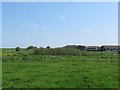
Fields and bushes at Reap Lane, Southwell
Many a rare bird has turned up in these bushes. When I visited I went to see the Great Spotted Cuckoo, but it sadly didn't oblige me with its presence.
Image: © Becky Williamson
Taken: 26 May 2016
0.11 miles
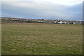
7
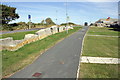
Southwell, footpath
From Reap Lane past modern housing to the coast.
Image: © Mike Faherty
Taken: 30 Aug 2014
0.13 miles
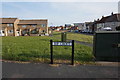
8

Southwell, Reap Lane Play Area
In the modern housing development.
Image: © Mike Faherty
Taken: 30 Aug 2014
0.13 miles
9
Houses on Avalanche Road
There is an OS benchmark Image on the right end house, #145, to the right of its white front door
Image: © Roger Templeman
Taken: 22 Sep 2012
0.14 miles
10

Benchmark on #145 Avalanche Road
Ordnance Survey cut mark benchmark described on the Bench Mark Database at http://www.bench-marks.org.uk/bm45547
Image: © Roger Templeman
Taken: 22 Sep 2012
0.14 miles