IMAGES TAKEN NEAR TO
Langley Close, PORTLAND, DT5 2DU
Introduction
This page details the photographs taken nearby to Langley Close, DT5 2DU by members of the Geograph project.
The Geograph project started in 2005 with the aim of publishing, organising and preserving representative images for every square kilometre of Great Britain, Ireland and the Isle of Man.

There are currently over 7.5m images from over14,400 individuals and you can help contribute to the project by visiting https://www.geograph.org.uk
Image Map
Images are licensed for reuse under creativecommons.org/licenses/by-sa/2.0
Notes
- Clicking on the map will re-center to the selected point.
- The higher the marker number, the further away the image location is from the centre of the postcode.
Image Listing (51 Images Found)
Images are licensed for reuse under creativecommons.org/licenses/by-sa/2.0
Image
Details
Distance
1
Southwell Road, Southwell
The southernmost community on the Portland plateau, originally established to house quarry-workers on the south-east coast of the island.
Image: © Jonathan Billinger
Taken: 19 May 2009
0.07 miles
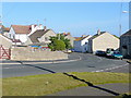
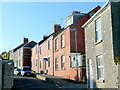
2
Sweet Hill Rd Southwell
View NE down Sweethill Rd on the southern edge of Southwell which loops through the northern edge of this square
Image: © Nigel Mykura
Taken: 8 Mar 2008
0.07 miles
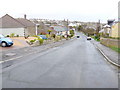
3
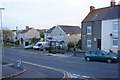
Sweet Hill Road: cars are allowed to park on the pavement (apparently)
Image: © Roger Templeman
Taken: 22 Sep 2012
0.07 miles
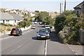
4
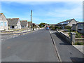
Avalanche Road towards Sweet Hill Road, Portland
Image: © Ian S
Taken: 29 May 2016
0.08 miles
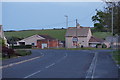
5
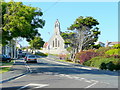
Avalanche Road, Southwell
The church of St. Andrew was built as a memorial to the lost mariners of 1210-ton three-masted iron sailing ship, The Avalanche, built 1874.
She was en route for Wellington, New Zealand in September 1877 with a cargo of pottery and glass.
Image: © Jonathan Billinger
Taken: 19 May 2009
0.10 miles
6
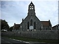
Portland-Southwell Church
The Church of Saint Andrew.
Image: © Ian Rob
Taken: 4 Sep 2008
0.10 miles
9
Church Lane, Southwell
Catching the last rays of spring evening sunshine.
A section of Dvorak's New World Symphony was going through my mind when I snapped this.
Image: © Jonathan Billinger
Taken: 19 May 2009
0.12 miles
10
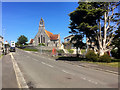
Southwell, Avalanche Road and Memorial Church
The Avalanche Memorial Church, also known as the Church of St Andrew, is a 19th-century Anglican parish church, located in Southwell village on the Isle of Portland.
In September 1877, two ships, the SS Avalanche and the SS Forest, collided off Portland Bill during stormy conditions. The Avalanche was taking 63 passengers to their homes in New Zealand. The Forest had a crew of 22. The disaster became national news, claiming the lives of 106 people. A new church was built as a memorial to those who had lost their lives. It was consecrated and dedicated to Saint Andrew by the Bishop of Salisbury on 3 July 1879.
The inside of St Andrew’s (Avalanche) Church is unique because it contains stained glass windows and memorials all associated with the collision of the Avalanche and Forest and the devastating loss of life. See http://www.geoffkirby.co.uk/Portland/685700/#Church (Geoff Kirby Exploring Portland) for interior photographs of the church showing some of the windows, memorials and artefacts from the ship. An interesting tour of the church (interior and exterior) by a camera carrying drone may be viewed at https://www.youtube.com/watch?v=M71ALx9vSgE (Chris Hornby Youtube).
The church, along with its boundary wall, has been a Grade II Listed building since September 1978 (List Entry Number: 1281886 http://www.heritagegateway.org.uk/Gateway/Results_Single.aspx?uid=1281886&resourceID=5 Heritage Gateway).
Image: © David Dixon
Taken: 17 Jun 2017
0.12 miles