IMAGES TAKEN NEAR TO
Sweet Hill Road, PORTLAND, DT5 2DS
Introduction
This page details the photographs taken nearby to Sweet Hill Road, DT5 2DS by members of the Geograph project.
The Geograph project started in 2005 with the aim of publishing, organising and preserving representative images for every square kilometre of Great Britain, Ireland and the Isle of Man.

There are currently over 7.5m images from over14,400 individuals and you can help contribute to the project by visiting https://www.geograph.org.uk
Image Map
Images are licensed for reuse under creativecommons.org/licenses/by-sa/2.0
Notes
- Clicking on the map will re-center to the selected point.
- The higher the marker number, the further away the image location is from the centre of the postcode.
Image Listing (36 Images Found)
Images are licensed for reuse under creativecommons.org/licenses/by-sa/2.0
Image
Details
Distance
1
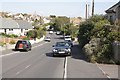
Sweet Hill Road: cars are allowed to park on the pavement (apparently)
Image: © Roger Templeman
Taken: 22 Sep 2012
0.03 miles
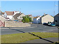
2
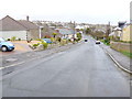
Sweet Hill Rd Southwell
View NE down Sweethill Rd on the southern edge of Southwell which loops through the northern edge of this square
Image: © Nigel Mykura
Taken: 8 Mar 2008
0.04 miles
4
Portland: postbox № DT5 145, Seven Acres
A small postbox in this bungalowy development in Southwell, southern Portland.
Image: © Chris Downer
Taken: 27 Dec 2008
0.13 miles
5
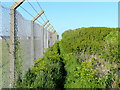
Footpath and fence
The security fence is on behalf of MOD property to the left.
Looking inland towards Sweet Hill.
Image: © Jonathan Billinger
Taken: 19 May 2009
0.15 miles
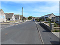
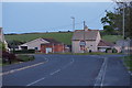
6
Southwell Road, Southwell
The southernmost community on the Portland plateau, originally established to house quarry-workers on the south-east coast of the island.
Image: © Jonathan Billinger
Taken: 19 May 2009
0.16 miles
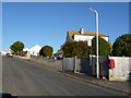
7
Avalanche Road towards Sweet Hill Road, Portland
Image: © Ian S
Taken: 29 May 2016
0.17 miles
8
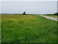
Top Fields
Grazing is now dominant around the Bill, the dry stone walls are gradually being repaired.
Image: © Hugh Venables
Taken: 13 May 2006
0.17 miles
9
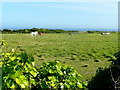
Horses in pasture
A field alongside the public footpath from Sweet Hill to the west coast of Portland.
Image: © Jonathan Billinger
Taken: 19 May 2009
0.17 miles
10
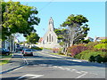
Avalanche Road, Southwell
The church of St. Andrew was built as a memorial to the lost mariners of 1210-ton three-masted iron sailing ship, The Avalanche, built 1874.
She was en route for Wellington, New Zealand in September 1877 with a cargo of pottery and glass.
Image: © Jonathan Billinger
Taken: 19 May 2009
0.18 miles