IMAGES TAKEN NEAR TO
Clarence Close, PORTLAND, DT5 2BG
Introduction
This page details the photographs taken nearby to Clarence Close, DT5 2BG by members of the Geograph project.
The Geograph project started in 2005 with the aim of publishing, organising and preserving representative images for every square kilometre of Great Britain, Ireland and the Isle of Man.

There are currently over 7.5m images from over14,400 individuals and you can help contribute to the project by visiting https://www.geograph.org.uk
Image Map
Images are licensed for reuse under creativecommons.org/licenses/by-sa/2.0
Notes
- Clicking on the map will re-center to the selected point.
- The higher the marker number, the further away the image location is from the centre of the postcode.
Image Listing (118 Images Found)
Images are licensed for reuse under creativecommons.org/licenses/by-sa/2.0
Image
Details
Distance
1
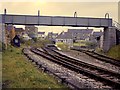
Easton station
Easton station on Portland. The branch had closed to passengers in 1952, but still handled good traffic. A parachute water tower was in use.
Image: © Richard Green
Taken: 4 Nov 1962
0.02 miles
2
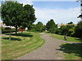
Public Gardens off Park Estate Road
These peaceful gardens are on the line of the track bed of the long dis-used railway line. Beyond the fence posts in the middle distance is Ladymead, built on the site of Easton station
Image: © Simon Palmer
Taken: 1 Jul 2008
0.04 miles
3
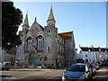
Portland: Easton Methodist Church
A church with a smart façade facing the village square.
Image: © Chris Downer
Taken: 27 Dec 2008
0.06 miles
4
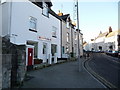
Portland: the old location of Easton Post Office
On Reforne, just as it leaves Easton Square. The post office closed on 6 December 2011 but reopened nearby on 8 May 2012 - see Image
The postbox was subsequently removed (some time in 2013) and replaced by a modern one near the new post office - see Image
Image: © Chris Downer
Taken: 27 Dec 2008
0.06 miles
5
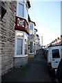
Portland: Grosvenor Road frontages
Identical bay windows, except for the colour in which the plasterwork is painted.
Image: © Chris Downer
Taken: 27 Dec 2008
0.07 miles
6
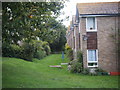
Dismantled Railway Garden
The line can be seen passing behind this block of sheltered housing.
Image: © Ivan Hall
Taken: 5 Sep 2009
0.07 miles
7
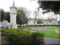
Easton, Portland
The clock tower in the small garden square at the centre of the town
Image: © Nigel Mykura
Taken: 8 Mar 2008
0.10 miles
8
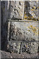
Benchmark on parapet pier of railway bridge, Reforne
Ordnance Survey cut mark benchmark described on the Bench Mark Database at http://www.bench-marks.org.uk/bm36216
Image: © Roger Templeman
Taken: 22 Sep 2012
0.10 miles
9
Portland: postbox № DT5 54, Grosvenor Road
This little Edward VII-reign postbox is set into a rather oversize stone pillar. Items need to have been posted in here by 4:15 weekdays, or 11:15am Saturdays, to catch the same day's post.
Image: © Chris Downer
Taken: 27 Dec 2008
0.10 miles
10
Wesleyan School
Grade II listed. https://historicengland.org.uk/listing/the-list/list-entry/1203081
Image: © N Chadwick
Taken: 29 Dec 2018
0.10 miles