IMAGES TAKEN NEAR TO
Mallams, PORTLAND, DT5 1NJ
Introduction
This page details the photographs taken nearby to Mallams, DT5 1NJ by members of the Geograph project.
The Geograph project started in 2005 with the aim of publishing, organising and preserving representative images for every square kilometre of Great Britain, Ireland and the Isle of Man.

There are currently over 7.5m images from over14,400 individuals and you can help contribute to the project by visiting https://www.geograph.org.uk
Image Map
Images are licensed for reuse under creativecommons.org/licenses/by-sa/2.0
Notes
- Clicking on the map will re-center to the selected point.
- The higher the marker number, the further away the image location is from the centre of the postcode.
Image Listing (280 Images Found)
Images are licensed for reuse under creativecommons.org/licenses/by-sa/2.0
Image
Details
Distance
1
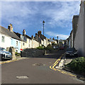
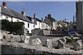
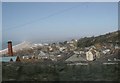
Mallams, Chiswell, Portland
Mallams climbs from Chiswell High Street to Fortuneswell.
Image: © Robin Stott
Taken: 16 Sep 2017
0.02 miles
2
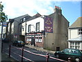
The New Star Inn, Fortuneswell, Portland, Dorset
Image: © Stacey Harris
Taken: 3 May 2009
0.02 miles
3
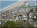
Fortuneswell, Isle of Portland
The principal town on the island.
Image: © Robin Webster
Taken: 3 Nov 2018
0.02 miles
5
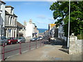
Mallams
Looking up Mallams from Chiswell High Street towards Fortuneswell.
Image: © mike smith
Taken: 6 May 2007
0.03 miles
6
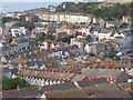
Fortuneswell
A view over the town's terraced houses. The prominent terrace on the opposite side is Ventnor Road. That's just above St John's church, the tower of which makes an appearance. In the foreground are the rooftops of Weare Close, Paul's Mead and St Martin's Road.
Image: © Andrew Smith
Taken: 9 Sep 2007
0.04 miles
7
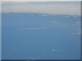
Portland and Chesil Beach
As seen from some distance, on a flight having just crossed the channel. The Fleet, behind the beach, and the walls of Portland Harbour can just be made out.
Image: © M J Richardson
Taken: 18 Aug 2010
0.04 miles
8
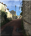
Northeast and uphill on King Street, Fortuneswell, Portland
King Street is one of a number of streets that run between Chiswell High Street and Fortuneswell.
Image: © Robin Stott
Taken: 16 Sep 2017
0.04 miles
9
Portland
This picture was taken on the descending road east of Chiswell looking towards West Bay.
Image: © Brendan and Ruth McCartney
Taken: Unknown
0.04 miles
10
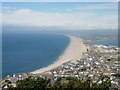
Chesil beach
This view of Chesil beach taken from above Fortuneswell shows how the shingle bar links the mainland with the Isle of Portland trapping the Fleet lagoon on its landward side.
Image: © Val Vannet
Taken: 17 Jul 2004
0.04 miles