IMAGES TAKEN NEAR TO
Tillycombe Road, PORTLAND, DT5 1LF
Introduction
This page details the photographs taken nearby to Tillycombe Road, DT5 1LF by members of the Geograph project.
The Geograph project started in 2005 with the aim of publishing, organising and preserving representative images for every square kilometre of Great Britain, Ireland and the Isle of Man.

There are currently over 7.5m images from over14,400 individuals and you can help contribute to the project by visiting https://www.geograph.org.uk
Image Map
Images are licensed for reuse under creativecommons.org/licenses/by-sa/2.0
Notes
- Clicking on the map will re-center to the selected point.
- The higher the marker number, the further away the image location is from the centre of the postcode.
Image Listing (181 Images Found)
Images are licensed for reuse under creativecommons.org/licenses/by-sa/2.0
Image
Details
Distance
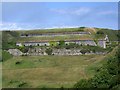
1
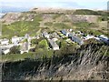
Houses in Tillycombe Road, Fortuneswell, Portland
Viewed from the road above.
Image: © Derek Voller
Taken: 3 Oct 2014
0.01 miles

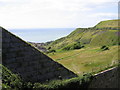
3
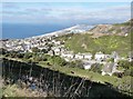
View from New Ground, Portland
Looking down the steep slope to Fortuneswell and beyond is curve of the Chesil Bank and the Fleet.
Image: © Maigheach-gheal
Taken: 15 Jun 2009
0.02 miles

5
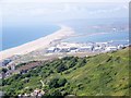
View across Fortuneswell to Chesil Beach beyond
Image: © Derek Voller
Taken: 3 Oct 2014
0.03 miles
6
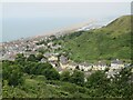
View over Fortuneswell, Isle of Portland
A view over Fortuneswell on the Isle of Portland. Chesil Beach can be seen in the distance, although this image was taken on a day when visibility was fairly poor.
Image: © Malc McDonald
Taken: 14 Aug 2021
0.03 miles
7
From New Ground
Verne Citadel left horizon, houses on left are at the end of Tillycombe Road
Image: © Chris Gunns
Taken: 25 May 2009
0.05 miles
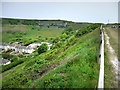
8
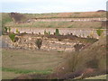
Merchants Railway, Isle of Portland
The wall in the right foreground is part of the dry "moat" surrounding the Verne prison. This deep vertical-walled cutting continues round the hillside above the grey stone screes on the right. Below this the path curving to disappear behind the diagonally sloping stone wall is the main line of the Merchants (or Portland) Railway that ran from Castletown, near the dockyard, to Priory Corner and quarries on the west side of the Isle.
Image: © A-M-Jervis
Taken: 6 Jul 2007
0.06 miles
9
Verne Battery, Portland
Built in the early 19th century to protect Portland Harbour.
Image: © Maigheach-gheal
Taken: 15 Jun 2009
0.07 miles