IMAGES TAKEN NEAR TO
Hambro Road, PORTLAND, DT5 1JU
Introduction
This page details the photographs taken nearby to Hambro Road, DT5 1JU by members of the Geograph project.
The Geograph project started in 2005 with the aim of publishing, organising and preserving representative images for every square kilometre of Great Britain, Ireland and the Isle of Man.

There are currently over 7.5m images from over14,400 individuals and you can help contribute to the project by visiting https://www.geograph.org.uk
Image Map
Images are licensed for reuse under creativecommons.org/licenses/by-sa/2.0
Notes
- Clicking on the map will re-center to the selected point.
- The higher the marker number, the further away the image location is from the centre of the postcode.
Image Listing (324 Images Found)
Images are licensed for reuse under creativecommons.org/licenses/by-sa/2.0
Image
Details
Distance
2
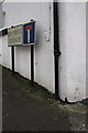
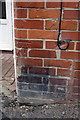
Benchmark on #2 Brymers Avenue
Ordnance Survey cut mark benchmark described on the Bench Mark Database at http://www.bench-marks.org.uk/bm40287
Image: © Roger Templeman
Taken: 21 Nov 2011
0.03 miles
4
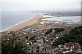
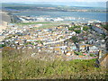
Portland and Chesil beach
Quite a view from here.
Image: © roger geach
Taken: 2 Jul 2010
0.03 miles
5
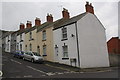
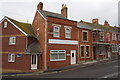
Houses on Brymers Avenue
There is an OS benchmark Image on the left front corner of the first house (on the Hambro Road face)
Image: © Roger Templeman
Taken: 21 Nov 2011
0.03 miles
6
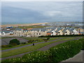
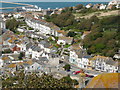
Fortuneswell - Houses
Modern housing with Chesil Beach in the background.
Image: © Chris Talbot
Taken: 19 Jun 2011
0.04 miles
7
Benchmark on #1 Hambro Road, 'Freiheit'
Ordnance Survey cut mark benchmark described on the Bench Mark Database at http://www.bench-marks.org.uk/bm40288
Image: © Roger Templeman
Taken: 21 Nov 2011
0.04 miles
8
Houses on Hambro Road
The house at the left end of the row, #1, has an OS benchmark Image on the corner under the Hambro Road road sign. This is at the junction with St Martins Road
Image: © Roger Templeman
Taken: 21 Nov 2011
0.04 miles
9
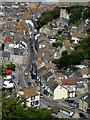
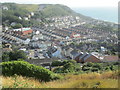
Road through Fortuneswell, Portland
Photographed from New Ground, one of the highest parts of the Isle of Portland. No photo can show the steepness of this road - the main access to the island.
Image: © John Goldsmith
Taken: 7 Jul 2009
0.04 miles