IMAGES TAKEN NEAR TO
Vindelis Way, PORTLAND, DT5 1FP
Introduction
This page details the photographs taken nearby to Vindelis Way, DT5 1FP by members of the Geograph project.
The Geograph project started in 2005 with the aim of publishing, organising and preserving representative images for every square kilometre of Great Britain, Ireland and the Isle of Man.

There are currently over 7.5m images from over14,400 individuals and you can help contribute to the project by visiting https://www.geograph.org.uk
Image Map
Images are licensed for reuse under creativecommons.org/licenses/by-sa/2.0
Notes
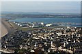
- Clicking on the map will re-center to the selected point.
- The higher the marker number, the further away the image location is from the centre of the postcode.
Image Listing (144 Images Found)
Images are licensed for reuse under creativecommons.org/licenses/by-sa/2.0
Image
Details
Distance
2
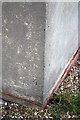
Benchmark on electricity substation, Verne Common Road
Ordnance Survey cut mark benchmark described on the Bench Mark Database at http://www.bench-marks.org.uk/bm40341
Image: © Roger Templeman
Taken: 22 Nov 2011
0.05 miles
3
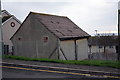
Electricity substation at a bend in Verne Common Road
There is an OS benchmark Image on the corner facing the camera.
Image: © Roger Templeman
Taken: 22 Nov 2011
0.05 miles
5
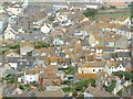
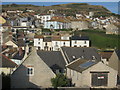
Fortuneswell from Castletown
Fortuneswell viewed from Castletown
Image: © Dave Mobley
Taken: 9 Jul 2006
0.07 miles
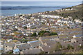
7
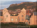
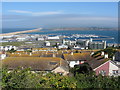
Portland: hillside housing
These houses, up the steep northern side of the isle of Portland, have commanding views across the harbour and over Chesil Beach. We are looking from the top of the zigzagging Verne Common Road, outside the Image
Image: © Chris Downer
Taken: 27 Dec 2008
0.07 miles
9
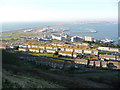
Portland marina and Chesil Beach from Fortuneswell
Image: © Gareth James
Taken: 10 Jun 2017
0.07 miles
10
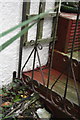
Benchmark on #83 Verne Common Road
Ordnance Survey cut mark benchmark seen through gate below tellis and described on the Bench Mark Database at http://www.bench-marks.org.uk/bm40339
Image: © Roger Templeman
Taken: 22 Nov 2011
0.08 miles