IMAGES TAKEN NEAR TO
Officers Field, PORTLAND, DT5 1FH
Introduction
This page details the photographs taken nearby to Officers Field, DT5 1FH by members of the Geograph project.
The Geograph project started in 2005 with the aim of publishing, organising and preserving representative images for every square kilometre of Great Britain, Ireland and the Isle of Man.

There are currently over 7.5m images from over14,400 individuals and you can help contribute to the project by visiting https://www.geograph.org.uk
Image Map
Images are licensed for reuse under creativecommons.org/licenses/by-sa/2.0
Notes
- Clicking on the map will re-center to the selected point.
- The higher the marker number, the further away the image location is from the centre of the postcode.
Image Listing (198 Images Found)
Images are licensed for reuse under creativecommons.org/licenses/by-sa/2.0
Image
Details
Distance
1
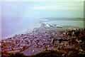
View over Fortuneswell towards Chesil Bank from New Ground, Portland Bill, 1981
The rows of tanks in the middle distance have since been replaced by industrial units.
Image: © Nigel Thompson
Taken: 30 Jul 1981
0.02 miles
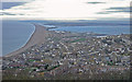
2
![Portland and Chesil Beach [3]](https://s0.geograph.org.uk/geophotos/06/78/29/6782992_7497537a_120x120.jpg)
Portland and Chesil Beach [3]
Seen from near the war memorial Image is this view over Fortuneswell toward Portland Harbour with Weymouth in the distance.
The Isle of Portland is a tied island, some 5 miles south of the resort of Weymouth, the southernmost point of the county of Dorset, joined to the mainland by Chesil Beach. The Isle has been inhabited since at least the Mesolithic period. Portland stone, a limestone famous for its use in world architecture is quarried here. Portland Harbour, is one of the largest man-made harbours in the world. Chesil Beach, a barrier beach, runs for 18 miles from West Bay to the Isle of Portland and in places is 50 feet high and 650 feet wide.
Image: © Michael Dibb
Taken: 11 Dec 2020
0.03 miles
3
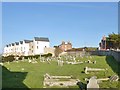
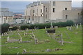
Fortuneswell, graveyard
Off Victory Road; looking disused.
Image: © Mike Faherty
Taken: 24 Jan 2015
0.04 miles
7
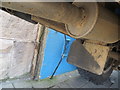
Ordnance Survey Flush Bracket 11779
This can be found on the wall of a building in Victoria Square, Portland.
For more detail see : http://www.bench-marks.org.uk/bm21578
Image: © Peter Wood
Taken: 5 Jun 2016
0.07 miles
8
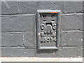
Ordnance Survey Flush Bracket G5014
This can be found on the wall of a building in Victoria Square, Portland.
For more detail see : http://www.bench-marks.org.uk/bm19169
Image: © Peter Wood
Taken: 5 Jun 2016
0.07 miles
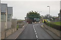
9
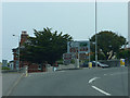
Junction of Victory Road and Castle Road,Fortuneswell
Image: © Chris Gunns
Taken: 25 May 2009
0.07 miles
10

Benchmark on Petrel Lodge, Victoria Square
Ordnance Survey flush bracket (serial number G5014) benchmark described on the Bench Mark Database at http://www.bench-marks.org.uk/bm19169
Image: © Roger Templeman
Taken: 21 Nov 2011
0.07 miles