IMAGES TAKEN NEAR TO
Mantle Close, PORTLAND, DT5 1ER
Introduction
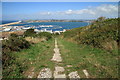
This page details the photographs taken nearby to Mantle Close, DT5 1ER by members of the Geograph project.
The Geograph project started in 2005 with the aim of publishing, organising and preserving representative images for every square kilometre of Great Britain, Ireland and the Isle of Man.

There are currently over 7.5m images from over14,400 individuals and you can help contribute to the project by visiting https://www.geograph.org.uk
Image Map
Images are licensed for reuse under creativecommons.org/licenses/by-sa/2.0
Notes
- Clicking on the map will re-center to the selected point.
- The higher the marker number, the further away the image location is from the centre of the postcode.
Image Listing (100 Images Found)
Images are licensed for reuse under creativecommons.org/licenses/by-sa/2.0
Image
Details
Distance
1
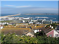
Portland marina and Chesil Beach from Fortuneswell
Image: © Gareth James
Taken: 10 Jun 2017
0.01 miles
2
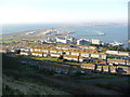
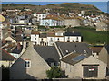
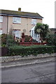
Portland: hillside housing
These houses, up the steep northern side of the isle of Portland, have commanding views across the harbour and over Chesil Beach. We are looking from the top of the zigzagging Verne Common Road, outside the Image
Image: © Chris Downer
Taken: 27 Dec 2008
0.03 miles
3
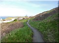
Fortuneswell, footpath
Through scrub on the slopes of Verne Cliffs.
Image: © Mike Faherty
Taken: 24 Jan 2015
0.04 miles
4
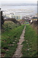
View down incline towards Portland Harbour
Image: © Roger Templeman
Taken: 22 Nov 2011
0.05 miles
5
Merchants Incline
Looking down the disused Inclined Plane towards Castletown and the harbour.
Image: © Guy Wareham
Taken: 31 Aug 2014
0.05 miles
6
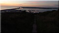
Merchant's Incline above Fortuneswell at dusk
Image: © Colin Park
Taken: 11 Oct 2021
0.06 miles
8
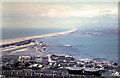
View across the rooftops of Chiswell 1962
Quite a few changes have taken place over the years. The number of storage tanks has reduced by a half and the sailing academy introduced. Chesil Beach disappears in the distance.
Image: © Gordon Spicer
Taken: Unknown
0.09 miles
9
#83 Verne Common Road
There is an OS benchmark Image on this house
Image: © Roger Templeman
Taken: 22 Nov 2011
0.09 miles
10
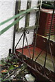
Benchmark on #83 Verne Common Road
Ordnance Survey cut mark benchmark seen through gate below tellis and described on the Bench Mark Database at http://www.bench-marks.org.uk/bm40339
Image: © Roger Templeman
Taken: 22 Nov 2011
0.09 miles