IMAGES TAKEN NEAR TO
The Verne, PORTLAND, DT5 1EG
Introduction
This page details the photographs taken nearby to The Verne, DT5 1EG by members of the Geograph project.
The Geograph project started in 2005 with the aim of publishing, organising and preserving representative images for every square kilometre of Great Britain, Ireland and the Isle of Man.

There are currently over 7.5m images from over14,400 individuals and you can help contribute to the project by visiting https://www.geograph.org.uk
Image Map
Images are licensed for reuse under creativecommons.org/licenses/by-sa/2.0
Notes
- Clicking on the map will re-center to the selected point.
- The higher the marker number, the further away the image location is from the centre of the postcode.
Image Listing (40 Images Found)
Images are licensed for reuse under creativecommons.org/licenses/by-sa/2.0
Image
Details
Distance
1
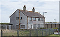
A derelict building at The Verne Prison, Fortuneswell
Located outside the secured area, near the Jailhouse Cafe.
Image: © Oliver Mills
Taken: 20 Aug 2016
0.01 miles
2
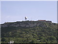
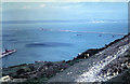
Cliffs & 'golfball' at north end of Isle of Portland
Looking up from the dockyard to the cliffs and the raised 'golfball' inside the grounds of the Verne prison.
Image: © Jacko
Taken: 16 May 2009
0.07 miles
3
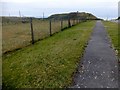
The Verne
High point about 80 metres from cafe car park after driving through the tunnel to the jail. Good views even on a grey afternoon then coffee and cake in the Jailhouse Cafe with Alex and Smudge.
Name: The Verne
Hill number: 5431
Height: 147m / 482ft
Parent (Ma/M): 2896 Lewesdon Hill
Section: 41: South Central England
County/UA: Dorset (CoU)
Class: HuMP, Tump (100-199m)
Grid ref: SY 69157 73869
Summit feature: concrete-topped grassy hump
Drop: 140m
Col: 7m SY666754
Image: © Rude Health
Taken: 27 Mar 2015
0.08 miles
4
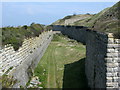
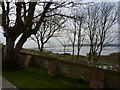
Moat surrounding the Verne Citadel, Portland
The Victorian defence works have been supplemented by some newer additions for HM Prison The Verne
Image: © Simon Palmer
Taken: 20 Apr 2008
0.12 miles
5
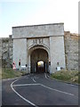
Portland: entrance to Verne prison
Having zigzagged all the way up Verne Common Road, we are met with this tunnel entrance to the Verne prison; no unauthorised access is available beyond this point. The traffic lights appear to be because of the width restriction rather than the security, because they turned green as soon as they sensed my approach.
Image: © Chris Downer
Taken: 27 Dec 2008
0.13 miles
6
Cattle on the steep slope of The Verne 1962
Bottom left is the naval cemetery and Portland Harbour beyond.
Image: © Gordon Spicer
Taken: Unknown
0.15 miles
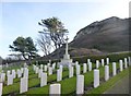
7
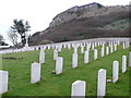
Navy cemetery, Portland
The cemetery sits on the northern slopes of the island under the steep cliffs
Image: © Nigel Mykura
Taken: 24 Mar 2008
0.16 miles
8
Trees, Portland
The view over Portland Harbour and up the fleet beyond is magnificent but omnipresent from the higher levels of this part of Portland. The presence of trees however is a lot rarer, owing to the high level of exposure of the island. These are to be found by the northern boundary wall of the naval cemetery. More trees exist further south by a bowls club Image .
Image: © Ivan Hall
Taken: 11 Apr 2010
0.16 miles
9
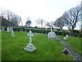
Castletown, cemetery
With different compartments, for military and civilian use.
Image: © Mike Faherty
Taken: 24 Jan 2015
0.17 miles
10
Castletown, war memorial
To those fallen in WWI and WWII; surrounded by war graves, and in the shadow of Verne Cliff.
Image: © Mike Faherty
Taken: 24 Jan 2015
0.18 miles