IMAGES TAKEN NEAR TO
Ayton Drive, PORTLAND, DT5 1EF
Introduction
This page details the photographs taken nearby to Ayton Drive, DT5 1EF by members of the Geograph project.
The Geograph project started in 2005 with the aim of publishing, organising and preserving representative images for every square kilometre of Great Britain, Ireland and the Isle of Man.

There are currently over 7.5m images from over14,400 individuals and you can help contribute to the project by visiting https://www.geograph.org.uk
Image Map
Images are licensed for reuse under creativecommons.org/licenses/by-sa/2.0
Notes
- Clicking on the map will re-center to the selected point.
- The higher the marker number, the further away the image location is from the centre of the postcode.
Image Listing (159 Images Found)
Images are licensed for reuse under creativecommons.org/licenses/by-sa/2.0
Image
Details
Distance
1
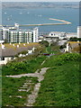
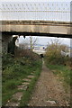
Merchants Railway, Portland
Built during the 19th century to transport newly quarried Portland stone to the jetty at Castletown. Working on the gravity principle fully laden trucks were the motive power to return empty ones to the top. View is now dominated by the old naval accommodation blocks, which have been converted into flats.
Image: © Simon Palmer
Taken: 20 Apr 2008
0.02 miles
2
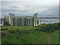
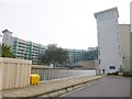
Atlantic House, Portland
Residential apartments above Portland Harbour.
Image: © John Allan
Taken: 18 May 2017
0.02 miles
3

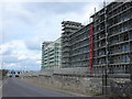
Apartment Block, Portland
New development overlooking Osprey Quay and the National Sailing Academy - just in time for sailing events at the 2012 Olympics.
http://en.wikipedia.org/wiki/Isle_of_Portland
Image: © Colin Smith
Taken: 14 Jan 2012
0.03 miles
4

Portland: New apartments overlooking 2012 Olympic Games venue
New apartments, overlooking Portland Harbour, with views of where the sailing events for the 2012 Olympics are to be held.
Image: © Mr Eugene Birchall
Taken: 14 Mar 2010
0.04 miles
5
New Apartments, Portland
These are old Naval barracks that are being converted to apartments overlooking Portland Harbour and Weymouth
Image: © Nigel Mykura
Taken: 24 Mar 2008
0.04 miles
6
Apartments, Portland, Dorset
New apartment block close to the leisure centre.
Image: © Christine Matthews
Taken: 12 Aug 2010
0.04 miles
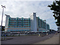
8
Castletown, Atlantic House
A horseshoe-shaped housing development overlooking Portland Harbour.
Image: © Mike Faherty
Taken: 13 Sep 2014
0.05 miles
9

Merchants Incline
Looking up from close to the bottom of the disused Inclined Plane. The SWCP follows the line of the old tramway.
Image: © Guy Wareham
Taken: 31 Aug 2014
0.05 miles
10
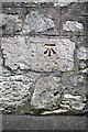
Benchmark on Castle Road wall
Ordnance Survey cut mark described on the Bench Mark Database at http://www.bench-marks.org.uk/bm40314
Image: © Roger Templeman
Taken: 22 Nov 2011
0.06 miles