IMAGES TAKEN NEAR TO
Ladymead Close, PORTLAND, DT5 1DY
Introduction
This page details the photographs taken nearby to Ladymead Close, DT5 1DY by members of the Geograph project.
The Geograph project started in 2005 with the aim of publishing, organising and preserving representative images for every square kilometre of Great Britain, Ireland and the Isle of Man.

There are currently over 7.5m images from over14,400 individuals and you can help contribute to the project by visiting https://www.geograph.org.uk
Image Map
Images are licensed for reuse under creativecommons.org/licenses/by-sa/2.0
Notes
- Clicking on the map will re-center to the selected point.
- The higher the marker number, the further away the image location is from the centre of the postcode.
Image Listing (117 Images Found)
Images are licensed for reuse under creativecommons.org/licenses/by-sa/2.0
Image
Details
Distance
1
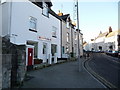
Portland: the old location of Easton Post Office
On Reforne, just as it leaves Easton Square. The post office closed on 6 December 2011 but reopened nearby on 8 May 2012 - see Image
The postbox was subsequently removed (some time in 2013) and replaced by a modern one near the new post office - see Image
Image: © Chris Downer
Taken: 27 Dec 2008
0.01 miles
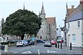
2
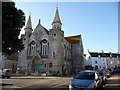
Portland: Easton Methodist Church
A church with a smart façade facing the village square.
Image: © Chris Downer
Taken: 27 Dec 2008
0.03 miles
3
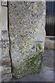
Benchmark on wall post on Reforne
Ordnance Survey cut mark benchmark described on the Bench Mark Database at http://www.bench-marks.org.uk/bm45669
Image: © Roger Templeman
Taken: 22 Sep 2012
0.04 miles
4
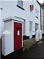
Portland: postbox № DT5 57, Reforne
This large, Elizabeth II-reign postbox stands outside what was previously Easton Post Office (see Image). The post office has recently moved into Martin's newsagents - see Image
(Update, 7 September 2013) The postbox has now been removed, and replaced by a modern box just up the road from the new post office: Image
Image: © Chris Downer
Taken: 25 Nov 2012
0.04 miles
5

Buxom Melons
One house on Reforne has a larger front window and a bay above it, indicating it may have been a small shop in its history. Above the door lintel is a provocative sign for American-grown greengrocery, which appears to have been put up around 2010 - it was already a house at the time.
Image: © Neil Owen
Taken: 11 Aug 2022
0.04 miles
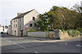
6

North face of Easton Methodist Church, Reforne
There is an OS benchmark Image on the stone wall post at the right hand edge of the image
Image: © Roger Templeman
Taken: 22 Sep 2012
0.04 miles
7
Easton Methodist Church
Grade II* listed. https://historicengland.org.uk/listing/the-list/list-entry/1280713
Image: © N Chadwick
Taken: 29 Dec 2018
0.04 miles
8
Junction of Reforne and Station Road with railway bridge
There is an OS benchmark Image on the near side of the parapet pier of the bridge which takes Reforne over a dismantled railway.
Image: © Roger Templeman
Taken: 22 Sep 2012
0.04 miles
9
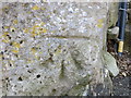
Ordnance Survey Cut Mark
This can be found on a stone post in Reforne, Easton.
For more detail see : http://www.bench-marks.org.uk/bm45669
Image: © Peter Wood
Taken: 5 Jun 2016
0.04 miles
10
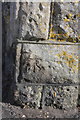
Benchmark on parapet pier of railway bridge, Reforne
Ordnance Survey cut mark benchmark described on the Bench Mark Database at http://www.bench-marks.org.uk/bm36216
Image: © Roger Templeman
Taken: 22 Sep 2012
0.05 miles