IMAGES TAKEN NEAR TO
Chiswell, PORTLAND, DT5 1AY
Introduction
This page details the photographs taken nearby to Chiswell, DT5 1AY by members of the Geograph project.
The Geograph project started in 2005 with the aim of publishing, organising and preserving representative images for every square kilometre of Great Britain, Ireland and the Isle of Man.

There are currently over 7.5m images from over14,400 individuals and you can help contribute to the project by visiting https://www.geograph.org.uk
Image Map
Images are licensed for reuse under creativecommons.org/licenses/by-sa/2.0
Notes
- Clicking on the map will re-center to the selected point.
- The higher the marker number, the further away the image location is from the centre of the postcode.
Image Listing (285 Images Found)
Images are licensed for reuse under creativecommons.org/licenses/by-sa/2.0
Image
Details
Distance
1
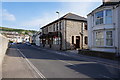
Beach House Tea Rooms & Hotel
Chiswell, Portland.
Image: © Ian S
Taken: 29 May 2016
0.02 miles
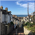
3
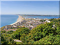
Fortuneswell
A view of Fortuneswell and the northern part of Portland Island from the top of the hill, near the War Memorial at Yeates Road.
Image: © David Dixon
Taken: 17 Jun 2017
0.04 miles
4
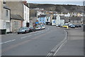
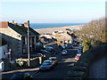
Chiswell High Street
This "high street" is devoid of shops. It is the main route north from Portland.
Image: © mike smith
Taken: 6 May 2007
0.04 miles
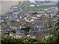
5
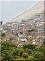
Portland roofscape (4)
Looking down from Verne Yeates toward Chesil Cove. The Cove House Inn is visible near the left-hand margin, its chimneys silhouetted against the shingle of the beach.
Image: © Stefan Czapski
Taken: 23 Aug 2012
0.04 miles
6
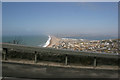
Chesil Beach
Looking west along Chesil Beach on a hazy March morning from the steep road leading to Easton on Portland.
Image: © Brendan and Ruth McCartney
Taken: 17 Mar 2005
0.04 miles
7
Portland: looking down Queens Road
Chesil Beach provides a stark border between sea and townscape.
Image: © Chris Downer
Taken: 27 Dec 2008
0.04 miles
8
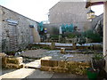
Portland: Chiswell Walled Garden
This garden stands on the site of a Jacobean Portland-stone house. In November 1824 a huge gale brought waves over the Chesil Bank, taking 26 lives and 80 houses with them. The village of Chiswell gradually declined, and the house on this site was demolished for the widening of the main road. The site was used in the Second World War to accommodate an concrete air-raid shelter, while in the 60s it was tarmacked over as a council yard.
It has recently been converted into this pleasant community garden, with assistance from the Countryside Agency and the Local Heritage Initiative.
Image: © Chris Downer
Taken: 27 Dec 2008
0.04 miles
9
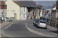
Descending Higher Lane, Chiswell, Portland
Higher Lane drops steeply from Castle Road to Chiswell High Street. The impressive dead flower spikes are of one of the giant lobelias, native only to the East African mountains that include Kilimanjaro.
Portland is extraordinary.
Image: © Robin Stott
Taken: 16 Sep 2017
0.05 miles
10
Portland roofscape (3)
A wider view than in the two previous items in this sequence. At top-left is the ridge of Chesil Beach, with Chiswell sheltered on its landward side. At the top of the picture the A354 heads for the mainland, skirting the industrial area which once accommodated HMS Osprey: http://www.geograph.org.uk/photo/2404928 http://www.geograph.org.uk/photo/2422887 From Victoria Square (just short of the green area) the road which now serves the Olympic Village curves round toward Castletown.
Image: © Stefan Czapski
Taken: 23 Aug 2012
0.05 miles