IMAGES TAKEN NEAR TO
Chiswell, PORTLAND, DT5 1AW
Introduction
This page details the photographs taken nearby to Chiswell, DT5 1AW by members of the Geograph project.
The Geograph project started in 2005 with the aim of publishing, organising and preserving representative images for every square kilometre of Great Britain, Ireland and the Isle of Man.

There are currently over 7.5m images from over14,400 individuals and you can help contribute to the project by visiting https://www.geograph.org.uk
Image Map
Images are licensed for reuse under creativecommons.org/licenses/by-sa/2.0
Notes
- Clicking on the map will re-center to the selected point.
- The higher the marker number, the further away the image location is from the centre of the postcode.
Image Listing (284 Images Found)
Images are licensed for reuse under creativecommons.org/licenses/by-sa/2.0
Image
Details
Distance
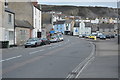
1
Beach House Tea Rooms & Hotel
Chiswell, Portland.
Image: © Ian S
Taken: 29 May 2016
0.01 miles
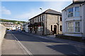
3
Chiswell High Street
This "high street" is devoid of shops. It is the main route north from Portland.
Image: © mike smith
Taken: 6 May 2007
0.02 miles
4
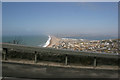
Chesil Beach
Looking west along Chesil Beach on a hazy March morning from the steep road leading to Easton on Portland.
Image: © Brendan and Ruth McCartney
Taken: 17 Mar 2005
0.02 miles
5
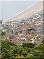
Portland roofscape (4)
Looking down from Verne Yeates toward Chesil Cove. The Cove House Inn is visible near the left-hand margin, its chimneys silhouetted against the shingle of the beach.
Image: © Stefan Czapski
Taken: 23 Aug 2012
0.03 miles
6
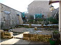
Portland: Chiswell Walled Garden
This garden stands on the site of a Jacobean Portland-stone house. In November 1824 a huge gale brought waves over the Chesil Bank, taking 26 lives and 80 houses with them. The village of Chiswell gradually declined, and the house on this site was demolished for the widening of the main road. The site was used in the Second World War to accommodate an concrete air-raid shelter, while in the 60s it was tarmacked over as a council yard.
It has recently been converted into this pleasant community garden, with assistance from the Countryside Agency and the Local Heritage Initiative.
Image: © Chris Downer
Taken: 27 Dec 2008
0.03 miles
7

Chiswell, gabions
At the southern end of Chesil Beach.
Image: © Mike Faherty
Taken: 31 Jan 2015
0.04 miles
9
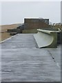
Sea defences by the Cove House Inn, Chiswell
In the distance is the ridge of Chesil Beach, nearer the camera the boxy shape of 'Cove Inn Castle', while in the foreground is a section of lipped concrete seawall, protecting the Cove House Inn (just out of shot to the right).
The 'castle' is built of beach pebbles, contained in wire cages (mostly cube-shaped). I'm not altogether clear about its purpose, but imagine it is intended to stabilise this section of the shingle ridge. There are 'Danger - Keep off' signs, but local kids make use of it as an adventure playground. I notice that since I was here in May 2011 the authorities have given in to reality by providing steps to the top.
Incidentally, an Environment Agency sign attached to the 'castle' gives a grid reference (SY 6817 7382) which I am quite unable to reconcile with the mapping.
Image: © Stefan Czapski
Taken: 24 Aug 2012
0.04 miles
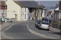
10
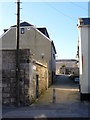
Portland: Lerret Ope
One of several small alleyways off Chiswell leading to the back side of Chesil Beach. They tend to end in the word Ope.
Image: © Chris Downer
Taken: 27 Dec 2008
0.04 miles