IMAGES TAKEN NEAR TO
Corscombe, DORCHESTER, DT2 0QF
Introduction
This page details the photographs taken nearby to DT2 0QF by members of the Geograph project.
The Geograph project started in 2005 with the aim of publishing, organising and preserving representative images for every square kilometre of Great Britain, Ireland and the Isle of Man.

There are currently over 7.5m images from over14,400 individuals and you can help contribute to the project by visiting https://www.geograph.org.uk
Image Map
Images are licensed for reuse under creativecommons.org/licenses/by-sa/2.0
Notes
- Clicking on the map will re-center to the selected point.
- The higher the marker number, the further away the image location is from the centre of the postcode.
Image Listing (7 Images Found)
Images are licensed for reuse under creativecommons.org/licenses/by-sa/2.0
Image
Details
Distance
1
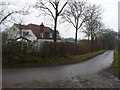
Ryewater Farm near Corscombe
Ryewater farm sits on a bend in the very quiet back road near Corscombe
Image: © Nigel Mykura
Taken: 4 Jan 2008
0.02 miles
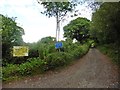
4
A woodland stream - Ryewater Lane
The stream flows under the bridge and on to Sutton Bingham Reservoir passing between Higher and Lower Halstock Leigh.
Image: © Sarah Smith
Taken: 17 Jun 2010
0.18 miles
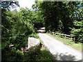
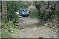
5
Ford at Corscombe
This is the second of the two byway fords at Corscombe.
Image: © John Walton
Taken: 20 Mar 2016
0.19 miles
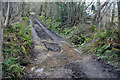
6
Ford at Corscombe
This is the first of two byway fords at Corscombe.
Image: © John Walton
Taken: 20 Mar 2016
0.22 miles
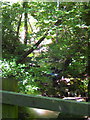
7
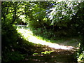
A shaft of light - Corscombe
Leaving the village of Corscombe by Lovelands the narrow lane is very dark overhung with trees when suddenly one comes upon a shaft of light streaming through a gateway over a small ford and where a track continues off into the countryside.
Image: © Sarah Smith
Taken: 17 Jun 2010
0.23 miles