IMAGES TAKEN NEAR TO
Corscombe, DORCHESTER, DT2 0NP
Introduction
This page details the photographs taken nearby to DT2 0NP by members of the Geograph project.
The Geograph project started in 2005 with the aim of publishing, organising and preserving representative images for every square kilometre of Great Britain, Ireland and the Isle of Man.

There are currently over 7.5m images from over14,400 individuals and you can help contribute to the project by visiting https://www.geograph.org.uk
Image Map
Images are licensed for reuse under creativecommons.org/licenses/by-sa/2.0
Notes
- Clicking on the map will re-center to the selected point.
- The higher the marker number, the further away the image location is from the centre of the postcode.
Image Listing (6 Images Found)
Images are licensed for reuse under creativecommons.org/licenses/by-sa/2.0
Image
Details
Distance
2
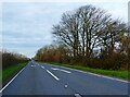
Field, Urless Farm
A view from the A356, with a bridleway following the combe on the left down past farm (out of sight - see Image).
Image: © Derek Harper
Taken: 22 Apr 2015
0.19 miles
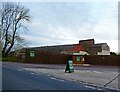
3
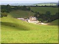
Urless Farm, Corscombe
Looking down across undulating pastures from the A356. Building works are currently taking place at the farm. According to the planning application notice these involve converting disused stables into a farm office and staff accommodation.
Image: © Andrew Smith
Taken: 15 Sep 2007
0.21 miles
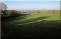
4
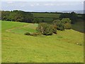
Pastures, Corscombe
The hillside above Urless Farm, with what looks like the ubiquitous strip of maize for gamebird cover.
Image: © Andrew Smith
Taken: 15 Sep 2007
0.22 miles