IMAGES TAKEN NEAR TO
Hectors Way, BLANDFORD FORUM, DT11 9QP
Introduction
This page details the photographs taken nearby to Hectors Way, DT11 9QP by members of the Geograph project.
The Geograph project started in 2005 with the aim of publishing, organising and preserving representative images for every square kilometre of Great Britain, Ireland and the Isle of Man.

There are currently over 7.5m images from over14,400 individuals and you can help contribute to the project by visiting https://www.geograph.org.uk
Image Map (Loading...)


Getting Data...Please wait
Leaflet Map data © OpenStreetMap
Images are licensed for reuse under creativecommons.org/licenses/by-sa/2.0
Notes
- Clicking on the map will re-center to the selected point.
- The higher the marker number, the further away the image location is from the centre of the postcode.
Image Listing (5 Images Found)
Images are licensed for reuse under creativecommons.org/licenses/by-sa/2.0
Image
Details
Distance
1
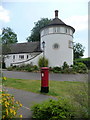
Blandford St. Mary: postbox № DT11 300, Folly Lane
A large, modern postbox serving a very new development of housing in Blandford St. Mary. It is emptied at 9:45 each morning, except Sunday.
Image: © Chris Downer
Taken: 27 Jun 2009
0.06 miles
2
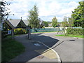
Entrance to Blandford St Mary CE Primary School
Image: © Alex McGregor
Taken: 23 Sep 2015
0.17 miles
3
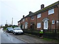
Cottages at Lower Bryanston
These cottages are close to Blanford St Mary on the south side of the River Stour at the eastern end of Fairmile Rd.
Image: © Nigel Mykura
Taken: 16 Jan 2010
0.21 miles