IMAGES TAKEN NEAR TO
Abbey View, BLANDFORD FORUM, DT11 9DU
Introduction
This page details the photographs taken nearby to Abbey View, DT11 9DU by members of the Geograph project.
The Geograph project started in 2005 with the aim of publishing, organising and preserving representative images for every square kilometre of Great Britain, Ireland and the Isle of Man.

There are currently over 7.5m images from over14,400 individuals and you can help contribute to the project by visiting https://www.geograph.org.uk
Image Map
Images are licensed for reuse under creativecommons.org/licenses/by-sa/2.0
Notes
- Clicking on the map will re-center to the selected point.
- The higher the marker number, the further away the image location is from the centre of the postcode.
Image Listing (22 Images Found)
Images are licensed for reuse under creativecommons.org/licenses/by-sa/2.0
Image
Details
Distance
1

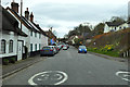
Spetisbury: postbox № DT11 55
This postbox stands outside the garage and is emptied at 11am on weekdays and at 10am on Saturdays. I believe the garage used also to be the post office which closed on 7 July 1989.
Being a southeast-northeast facing road, with properties all along the southwestern side, the road does not see much sun in the winter and you can see that the ice did not thaw all day on these cars – the picture was taken around 2pm and it was a beautifully sunny day, while it had been about -4ºC overnight.
Image: © Chris Downer
Taken: 7 Dec 2008
0.04 miles
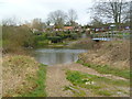
2
Spetisbury Ford
This ford at Spetisbury affords access to the disused cricket pitch from the main A350. A video of the ford can be seen at:
https://youtu.be/7vm5QbPvv_w
Image: © John Walton
Taken: 24 Jan 2016
0.08 miles
3
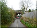
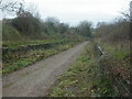
Spetisbury, disused railway bridge
Once carrying the S&DJR across the lane to South Farm; the trackbed is now a trailway from Spetisbury to Charlton Marshall.
Image: © Mike Faherty
Taken: 25 Jan 2012
0.08 miles
4
Spetisbury, ford
Across an arm of the Stour towards Bournemouth Road, with a footbridge next to it for the less adventurous.
Image: © Mike Faherty
Taken: 25 Jan 2012
0.09 miles
5
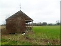
Spetisbury, cricket pavilion
Overlooking the cricket ground; it looks as if the pavilion has seen better days. Note the batsman weathervane.
Image: © Mike Faherty
Taken: 25 Jan 2012
0.11 miles
6
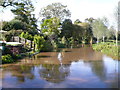
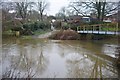
River Stour at Spetisbury
The river is very high due to recent rain and the water is starting to lap over in to the gardens of the houses along the river.
Image: © Nigel Mykura
Taken: 6 Oct 2012
0.11 miles
7
Old railway station, Spetisbury
All that remains of the station are the steps down to street level, and the platforms. Spetisbury Station was opened in 1860, became later part of the Somerset & Dorset Joint Railway, and was closed in 1956.
http://www.trainweb.org/railwest/railco/sdjr/spetis.html
Image: © Mike Faherty
Taken: 29 Nov 2008
0.15 miles
8
A350 through Spetisbury
Heading south. The RAF flag is doubtless being flown to commemorate the centenary of the founding of the RAF on 1 April 1918.
Image: © Robin Webster
Taken: 1 Apr 2018
0.16 miles
9
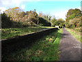
Spetisbury Halt, abandoned platform
The trackbed, formerly belonging to the Somerset and Dorset Joint Railway, now forms a recreational linear trail. On the historic OS map the village of Spetisbury is spelt with two t's.
Image: © michael ely
Taken: 27 Oct 2010
0.18 miles
10
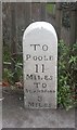
Old Milestone by the A350, Spetisbury
Carved stone post by the A350, in parish of SPETISBURY (NORTH DORSET District), 30m East of Drax Arms PH, on narrow pavement, on East side of road. Dorset 3 (limestone), erected by the Blandford & Poole turnpike trust in the 19th century.
N.B. Not at listed location, actually in front of #26 High Street, Fisher Cottages.
Inscription reads:-
TO
POOLE
11
MILES
TO
BLANDFORD
3
MILES
Grade II Listed. List Entry Number:1324662
https://historicengland.org.uk/listing/the-list/list-entry/1324662
Milestone Society National ID: DO_POBF11.
Image: © J Tybjerg
Taken: 18 Jun 2002
0.18 miles