IMAGES TAKEN NEAR TO
Spetisbury, BLANDFORD FORUM, DT11 9DH
Introduction
This page details the photographs taken nearby to DT11 9DH by members of the Geograph project.
The Geograph project started in 2005 with the aim of publishing, organising and preserving representative images for every square kilometre of Great Britain, Ireland and the Isle of Man.

There are currently over 7.5m images from over14,400 individuals and you can help contribute to the project by visiting https://www.geograph.org.uk
Image Map
Images are licensed for reuse under creativecommons.org/licenses/by-sa/2.0
Notes
- Clicking on the map will re-center to the selected point.
- The higher the marker number, the further away the image location is from the centre of the postcode.
Image Listing (2 Images Found)
Images are licensed for reuse under creativecommons.org/licenses/by-sa/2.0
Image
Details
Distance
1
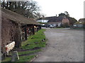
North Farm
This dairy farm nestles in the valley bottom about 1 mile west of Spetisbury
Image: © Brian Ironside
Taken: 4 Feb 2007
0.04 miles
2
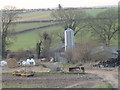
Silo at North Farm
North Farm viewed from the footpath to the South East that runs between South Farm and North Farm
Image: © Brian Ironside
Taken: 4 Feb 2007
0.08 miles