IMAGES TAKEN NEAR TO
Charisworth, BLANDFORD FORUM, DT11 9AL
Introduction
This page details the photographs taken nearby to DT11 9AL by members of the Geograph project.
The Geograph project started in 2005 with the aim of publishing, organising and preserving representative images for every square kilometre of Great Britain, Ireland and the Isle of Man.

There are currently over 7.5m images from over14,400 individuals and you can help contribute to the project by visiting https://www.geograph.org.uk
Image Map
Images are licensed for reuse under creativecommons.org/licenses/by-sa/2.0
Notes
- Clicking on the map will re-center to the selected point.
- The higher the marker number, the further away the image location is from the centre of the postcode.
Image Listing (5 Images Found)
Images are licensed for reuse under creativecommons.org/licenses/by-sa/2.0
Image
Details
Distance
2
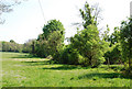
Course of Combs Ditch
The ditch follows the tree line.
Image: © Toby
Taken: 5 May 2007
0.19 miles
5

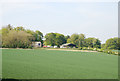
Absence of Chimney
Marked as Chy on the map (which I believe should mean a chimney). In fact some kind of industrial/agricultural site for treatment/storage of grain. We thought it was owned by Collinson but have discovered that they just make the silos.
Image: © Toby
Taken: 5 May 2007
0.24 miles