IMAGES TAKEN NEAR TO
Pimperne, BLANDFORD FORUM, DT11 8TU
Introduction
This page details the photographs taken nearby to DT11 8TU by members of the Geograph project.
The Geograph project started in 2005 with the aim of publishing, organising and preserving representative images for every square kilometre of Great Britain, Ireland and the Isle of Man.

There are currently over 7.5m images from over14,400 individuals and you can help contribute to the project by visiting https://www.geograph.org.uk
Image Map (Loading...)


Getting Data...Please wait
Leaflet Map data © OpenStreetMap
Images are licensed for reuse under creativecommons.org/licenses/by-sa/2.0
Notes
- Clicking on the map will re-center to the selected point.
- The higher the marker number, the further away the image location is from the centre of the postcode.
Image Listing (17 Images Found)
Images are licensed for reuse under creativecommons.org/licenses/by-sa/2.0
Image
Details
Distance
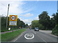
2
A354, Pimperne
Ahead is one of the buildings on an industrial estate.
Image: © Robin Webster
Taken: 1 Apr 2018
0.05 miles
3
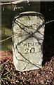
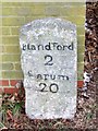
Old Milestone, A354, Salisbury Road, Pimperne
The milestone is located against the brick wall on the west side of the road opposite the Yarde Farm housing development. Parish of Pimperne (North Dorset District). Carved stone post, Dorset 3 (limestone), erected by the Harnham, Blandford & Dorchester turnpike trust in the 19th century.
Inscription reads:-
Blandford
2
Sarum
20
Grade II Listed. List Entry Number:1324315
https://historicengland.org.uk/listing/the-list/list-entry/1324315
Milestone Society National ID: DO_BFSA02
Image: © Mike Faherty
Taken: 3 Feb 2007
0.06 miles
4
Milestone, Pimperne
The stone milestone was erected in the late 18th or early 19th century by the Harnham, Blandford and Dorchester Trust. The legend reads Blandford 2, Sarum 16.
Image: © Maigheach-gheal
Taken: 10 Jan 2010
0.07 miles
5
Milestone, Pimperne
The stone milestone was erected in the late 18th or early 19th century by the Harnham, Blandford and Dorchester Trust. The legend reads Blandford 2, Sarum 16. For a wider view see Image
Image: © Maigheach-gheal
Taken: 10 Jan 2010
0.08 miles
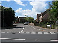
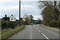
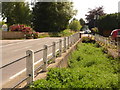
7
Salisbury Road, Pimperne
I'm not sure what the barriers were doing.
Image: © David Howard
Taken: 20 Jun 2020
0.14 miles
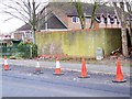
8
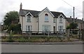
House on Chapel Lane, Pimperne
From Salisbury Road
Image: © David Howard
Taken: 20 Jun 2020
0.15 miles
9
Pimperne: stream between A354 and Chapel Lane
Chapel Lane runs to our right, accessed further up the village by motor traffic.
Image: © Chris Downer
Taken: 27 Jun 2009
0.16 miles
10
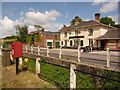
Pimperne: postbox № DT11 108, Chapel Lane
This small postbox stands between Chapel Lane and the main Salisbury Road, and is emptied at 10:30am on weekdays and half an hour earlier on Saturdays.
The Image is in the background.
Image: © Chris Downer
Taken: 27 Jun 2009
0.16 miles