IMAGES TAKEN NEAR TO
Iwerne Minster, BLANDFORD FORUM, DT11 8NL
Introduction
This page details the photographs taken nearby to DT11 8NL by members of the Geograph project.
The Geograph project started in 2005 with the aim of publishing, organising and preserving representative images for every square kilometre of Great Britain, Ireland and the Isle of Man.

There are currently over 7.5m images from over14,400 individuals and you can help contribute to the project by visiting https://www.geograph.org.uk
Image Map
Images are licensed for reuse under creativecommons.org/licenses/by-sa/2.0
Notes
- Clicking on the map will re-center to the selected point.
- The higher the marker number, the further away the image location is from the centre of the postcode.
Image Listing (8 Images Found)
Images are licensed for reuse under creativecommons.org/licenses/by-sa/2.0
Image
Details
Distance
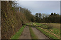
1
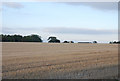
Up Preston Hill
Large field with farm building visible at the brow.
Image: © Toby
Taken: 19 Oct 2007
0.06 miles
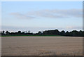
2
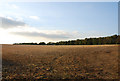
Preston Hill Farm
This area is clearly used for shooting more than farming. The farm can just be seen behind the trees.
Image: © Toby
Taken: 19 Oct 2007
0.10 miles
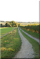
3
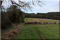
Wessex Ridgeway on Preston Hill
The long distance footpath between Preston Wood and the village of Iwerne Courtney.
Image: © Chris Heaton
Taken: 10 Feb 2020
0.17 miles
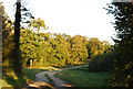
4
The Wessex Ridgeway path on Preston Hill
Approaching Preston Wood
Image: © Tim Heaton
Taken: 10 Feb 2020
0.17 miles
5
Wessex Ridgeway approaching Preston Wood
Image: © Chris Heaton
Taken: 10 Feb 2020
0.22 miles
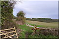
8
Track into Preston Wood
This forms part of the Wessex Ridgeway. The route from Shroton is not recommended for the unfit!
Image: © Toby
Taken: 19 Oct 2007
0.24 miles