IMAGES TAKEN NEAR TO
Farnham, BLANDFORD FORUM, DT11 8DD
Introduction
This page details the photographs taken nearby to DT11 8DD by members of the Geograph project.
The Geograph project started in 2005 with the aim of publishing, organising and preserving representative images for every square kilometre of Great Britain, Ireland and the Isle of Man.

There are currently over 7.5m images from over14,400 individuals and you can help contribute to the project by visiting https://www.geograph.org.uk
Image Map (Loading...)


Getting Data...Please wait
Leaflet Map data © OpenStreetMap
Images are licensed for reuse under creativecommons.org/licenses/by-sa/2.0
Notes
- Clicking on the map will re-center to the selected point.
- The higher the marker number, the further away the image location is from the centre of the postcode.
Image Listing (17 Images Found)
Images are licensed for reuse under creativecommons.org/licenses/by-sa/2.0
Image
Details
Distance
1
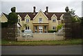
The old museum building
A pioneer in the field of Anthropology, General Augustus Henry Lane Fox Pitt Rivers, created his 'private' museum to display part of his collection in the 1880s. The building is now private residences. http://www.salisburymuseum.org.uk/galleries/index.php?Action=4&obID=102&prevID=43&oprevID=10
Image: © Nigel Freeman
Taken: 20 Aug 2006
0.09 miles
2
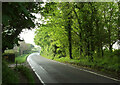
Road past Elham House
Larger sizes will help reveal, on the left, the "gate piers with ball finials" of Image https://historicengland.org.uk/listing/the-list/list-entry/1118520?section=official-list-entry . This is from the start of footpath E9 2 Image
Image: © Derek Harper
Taken: 7 May 2024
0.09 miles
3
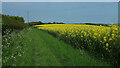
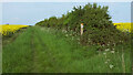
Oilseed rape on the Jubilee Trail
The trail is following bridleway E9 6 from Chettle towards Miller's Lane.
Image: © Derek Harper
Taken: 8 May 2024
0.16 miles
4
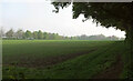
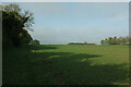
Crop, Farnham
Looking back across the field and along the headland path I've followed - see Image], The second footpath, E9 2, starts from here and heads diagonally to meet the lane halfway along the field.
Image: © Derek Harper
Taken: 7 May 2024
0.17 miles
5
Jubilee Trail near Chettle
Following bridleway E9 6, towards Farnham.
Image: © Derek Harper
Taken: 8 May 2024
0.17 miles
6
Crop, Farnham
Taken about 100 metres along the hedgeside path shown in Image Right of centre is Crossways Dairy Bungalow at Farnham Museum Cross.
Image: © Derek Harper
Taken: 7 May 2024
0.18 miles
7
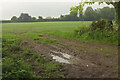
Arable field, Farnham
The point on the lane (between the village and Farnham Museum Cross) from which footpaths E9 1 and 2 should emanate. See also https://www.geograph.org.uk/search.php?i=211616280 .
Image: © Derek Harper
Taken: 7 May 2024
0.18 miles
8
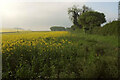
Oilseed rape near Farnham
Looking right from Image], with footpath E9 3 running along the edge of the field.
Image: © Derek Harper
Taken: 7 May 2024
0.20 miles
9
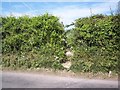
Footpath towards Farnham
The footpath leaves the road through the hedge.
Image: © Maigheach-gheal
Taken: 22 May 2007
0.20 miles
10
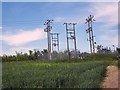
Electricity sub-station between Farnham and Minchington
Image: © Maigheach-gheal
Taken: 22 May 2007
0.21 miles