IMAGES TAKEN NEAR TO
Shaftesbury Lane, BLANDFORD FORUM, DT11 7TB
Introduction
This page details the photographs taken nearby to Shaftesbury Lane, DT11 7TB by members of the Geograph project.
The Geograph project started in 2005 with the aim of publishing, organising and preserving representative images for every square kilometre of Great Britain, Ireland and the Isle of Man.

There are currently over 7.5m images from over14,400 individuals and you can help contribute to the project by visiting https://www.geograph.org.uk
Image Map (Loading...)


Getting Data...Please wait
Leaflet Map data © OpenStreetMap
Images are licensed for reuse under creativecommons.org/licenses/by-sa/2.0
Notes
- Clicking on the map will re-center to the selected point.
- The higher the marker number, the further away the image location is from the centre of the postcode.
Image Listing (17 Images Found)
Images are licensed for reuse under creativecommons.org/licenses/by-sa/2.0
Image
Details
Distance
1
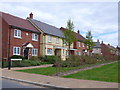
Houses on Warrington Walk
Warrington Walk is a short pedestrian road just off Ghurka Rd on a brand new housing estate. The terrace of houses is parallel to Shaftesbury lane and a short distance east of it.
Image: © Nigel Mykura
Taken: 3 May 2013
0.05 miles
2
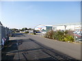
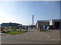
Blandford Heights Industrial Estate
Off Higher Shaftesbury Road.
Image: © Mike Faherty
Taken: 19 Feb 2013
0.08 miles
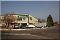
3
Blandford Heights Industrial estate
Part of the Blandford Heights Industrial estate the large building at the back left of the picture is the BOCM animal feeds mill, it dominates the landscape from its elevated position on the estate.
Image: © Marilyn Peddle
Taken: 12 Apr 2007
0.12 miles
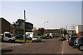
4
Industrial Estate
Blandford Heights Industrial estate, has a wide range of small to medium industries providing local employment.
Image: © Marilyn Peddle
Taken: 12 Apr 2007
0.14 miles
6
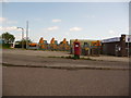
Blandford Forum: postbox № DT11 103, Blandford Heights Industrial Estate
A modern postbox, emptied finally at 5:30pm on weekdays and at 11am on Saturdays.
Image: © Chris Downer
Taken: 27 Jun 2009
0.15 miles
7
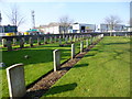
Blandford Forum, war graves
In Image; some of the 58 war graves here, from WWI, WWII and later; the large number is presumably explained by the proximity of Blandford Camp. http://en.tracesofwar.com/article/3751/Commonwealth-War-Graves-Blandford-Forum.htm
Image: © Mike Faherty
Taken: 19 Feb 2013
0.16 miles
8
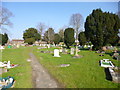
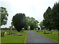
Blandford Cemetery
Municipal cemetery on Salisbury Road, with two chapels, war memorial and war graves: http://www.blandfordforum-tc.gov.uk/cemetery.html
Image: © Mike Faherty
Taken: 19 Feb 2013
0.19 miles
10
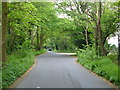
Tinpot Lane
A shady road on the outskirts of Blandford marked on the map as a public footpath, that leads to the Milldown and to an industrial estate.
Image: © Derek Harper
Taken: 6 May 2006
0.22 miles