IMAGES TAKEN NEAR TO
White Cliff Mill Street, BLANDFORD FORUM, DT11 7BQ
Introduction
This page details the photographs taken nearby to White Cliff Mill Street, DT11 7BQ by members of the Geograph project.
The Geograph project started in 2005 with the aim of publishing, organising and preserving representative images for every square kilometre of Great Britain, Ireland and the Isle of Man.

There are currently over 7.5m images from over14,400 individuals and you can help contribute to the project by visiting https://www.geograph.org.uk
Image Map (Loading...)


Getting Data...Please wait
Leaflet Map data © OpenStreetMap
Images are licensed for reuse under creativecommons.org/licenses/by-sa/2.0
Notes
- Clicking on the map will re-center to the selected point.
- The higher the marker number, the further away the image location is from the centre of the postcode.
Image Listing (257 Images Found)
Images are licensed for reuse under creativecommons.org/licenses/by-sa/2.0
Image
Details
Distance
1
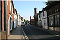
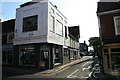
Salisbury Street, Blandford Forum
Looking north.
Image: © andrew auger
Taken: 16 Sep 2009
0.01 miles
2
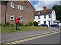
Blandford Forum: postbox № DT11 39, Eagle House Gardens
This modern postbox is emptied at 4:15pm on weekdays and at 11:30am on Saturdays.
Image: © Chris Downer
Taken: 27 Jun 2009
0.04 miles
3
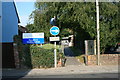
Blandford Health Centre
On Salisbury Street.
Image: © andrew auger
Taken: 16 Sep 2009
0.04 miles
4

Some aspects of Blandford's architecture: 24 White Cliff Mill Street (detail)
A colourful front door of a Grade II listed cottage in White Cliff Mill Street.
https://historicengland.org.uk/listing/the-list/list-entry/1108603
Image: © Mike Searle
Taken: 4 May 2014
0.05 miles
5
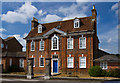
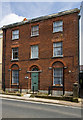
Some aspects of Blandford's architecture: Eagle House, White Cliff Mill Street
An early to mid C18 detached house, the ground floor of which once housed a glove factory. Listed Grade II.
https://historicengland.org.uk/listing/the-list/list-entry/1108642
Image: © Mike Searle
Taken: 4 May 2014
0.05 miles
6
The Plocks, Blandford Forum
Leading to The Close.
Image: © andrew auger
Taken: 16 Sep 2009
0.06 miles
7

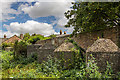
Defending Dorset in 1940: Blandford anti-tank island - cubes (5)
-
Anti-tank Block: DoB ID: S0000117
The largest concentration of surviving anti-tank cubes are to be found in a plot of waste ground behind a former deer park. Ten of the fifteen blocks can be seen in the above photo. They were once part of a series of cubes to the northwest of the town that followed a line to the south that joined a 280 metre long anti-tank ditch.
Image
Image: © Mike Searle
Taken: 8 Sep 2016
0.07 miles
8
Defending Dorset in 1940: Blandford anti-tank island - cubes (6)
-
Anti-tank Block: DoB ID: S0000117
Image
Image: © Mike Searle
Taken: 8 Sep 2016
0.07 miles
9
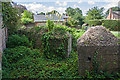
Defending Dorset in 1940: Blandford anti-tank island - cubes (7)
-
Anti-tank Block: DoB ID: S0000117
The remaining 5 cubes can be seen here in this view looking south.
Image
Image: © Mike Searle
Taken: 8 Sep 2016
0.07 miles
10
Some aspects of Blandford's architecture: 76 Salisbury Street
Early C19. This early C19 style whilst common elsewhere, is rare in Blandford. Listed Grade II.
https://historicengland.org.uk/listing/the-list/list-entry/1153166
Image: © Mike Searle
Taken: 4 May 2014
0.07 miles