IMAGES TAKEN NEAR TO
White Cliff Mill Street, BLANDFORD FORUM, DT11 7BP
Introduction
This page details the photographs taken nearby to White Cliff Mill Street, DT11 7BP by members of the Geograph project.
The Geograph project started in 2005 with the aim of publishing, organising and preserving representative images for every square kilometre of Great Britain, Ireland and the Isle of Man.

There are currently over 7.5m images from over14,400 individuals and you can help contribute to the project by visiting https://www.geograph.org.uk
Image Map (Loading...)


Getting Data...Please wait
Leaflet Map data © OpenStreetMap
Images are licensed for reuse under creativecommons.org/licenses/by-sa/2.0
Notes
- Clicking on the map will re-center to the selected point.
- The higher the marker number, the further away the image location is from the centre of the postcode.
Image Listing (82 Images Found)
Images are licensed for reuse under creativecommons.org/licenses/by-sa/2.0
Image
Details
Distance
1
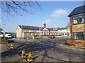
Blandford Forum, The Forum Centre
Children's centre and pupil referral centre, on Black Lane; a blue plaque informs that the site was originally a national school, and later Archbishop Wake CoE School, 1840-2009: http://www.dorsetforyou.com/childrenscentres/blandford
Image: © Mike Faherty
Taken: 19 Feb 2013
0.05 miles
3
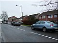
Park Road
Park road is part of the B3082 as it enters the town on its western side. it becomes Damory Street which then runs into East Street at the junction with Wimborne Rd.
Image: © Nigel Mykura
Taken: 16 Jan 2010
0.06 miles
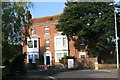
4
Blandford Health Centre
On Salisbury Street.
Image: © andrew auger
Taken: 16 Sep 2009
0.08 miles
5

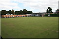
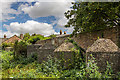
Defending Dorset in 1940: Blandford anti-tank island - cubes (5)
-
Anti-tank Block: DoB ID: S0000117
The largest concentration of surviving anti-tank cubes are to be found in a plot of waste ground behind a former deer park. Ten of the fifteen blocks can be seen in the above photo. They were once part of a series of cubes to the northwest of the town that followed a line to the south that joined a 280 metre long anti-tank ditch.
Image
Image: © Mike Searle
Taken: 8 Sep 2016
0.09 miles
6
Defending Dorset in 1940: Blandford anti-tank island - cubes (6)
-
Anti-tank Block: DoB ID: S0000117
Image
Image: © Mike Searle
Taken: 8 Sep 2016
0.09 miles
7
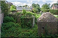
Defending Dorset in 1940: Blandford anti-tank island - cubes (7)
-
Anti-tank Block: DoB ID: S0000117
The remaining 5 cubes can be seen here in this view looking south.
Image
Image: © Mike Searle
Taken: 8 Sep 2016
0.09 miles
8
Langham House, Blandford Forum
On the corner of Park Road and Salisbury Street.
Image: © andrew auger
Taken: 16 Sep 2009
0.10 miles
9
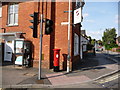
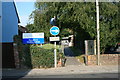
Blandford Forum: postbox № DT11 1 and phone, Park Road
The George VI-reign postbox is emptied finally at 4pm on weekdays and at 11:30am on Saturdays. To the right, we look up Salisbury Road, which, as its name suggests, is the main road out of town towards the Wiltshire city.
Image: © Chris Downer
Taken: 8 Aug 2009
0.10 miles
10

Blandford Community Hospital
On Milldown Road; centre, entrance to the Minor Injuries Unit: http://www.nhs.uk/Services/hospitals/Overview/DefaultView.aspx?id=30100
Image: © Mike Faherty
Taken: 19 Feb 2013
0.10 miles