IMAGES TAKEN NEAR TO
Old Oak Way, BLANDFORD FORUM, DT11 0TN
Introduction
This page details the photographs taken nearby to Old Oak Way, DT11 0TN by members of the Geograph project.
The Geograph project started in 2005 with the aim of publishing, organising and preserving representative images for every square kilometre of Great Britain, Ireland and the Isle of Man.

There are currently over 7.5m images from over14,400 individuals and you can help contribute to the project by visiting https://www.geograph.org.uk
Image Map (Loading...)


Getting Data...Please wait
Leaflet Map data © OpenStreetMap
Images are licensed for reuse under creativecommons.org/licenses/by-sa/2.0
Notes
- Clicking on the map will re-center to the selected point.
- The higher the marker number, the further away the image location is from the centre of the postcode.
Image Listing (86 Images Found)
Images are licensed for reuse under creativecommons.org/licenses/by-sa/2.0
Image
Details
Distance
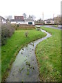
1
Winterborne Whitechurch, road bridge
Carrying Fosters Meadows over River Winterborne.
Image: © Mike Faherty
Taken: 1 Mar 2013
0.07 miles
2
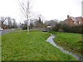
Winterborne Whitechurch, River Winterborne
Looking downstream from Image One of two Dorset rivers bearing this name, this is the North Winterborne. Winterbournes flow in winter, fed by aquifers, and often dry out in summer. http://www.england-in-particular.info/stour/s-winterborne.html
Image: © Mike Faherty
Taken: 1 Mar 2013
0.07 miles
3
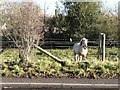
Winterborne Whitechurch: little pony
The only white one in a small group of ponies in a field alongside Whatcombe Lane; he came across as I pulled up, but none of his friends seemed interested.
Image: © Chris Downer
Taken: 7 Dec 2008
0.07 miles
4
Winterborne Whitechurch: Field?s Close
A small development of semi-detached houses just off the village centre.
Image: © Chris Downer
Taken: 7 Dec 2008
0.07 miles
5
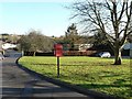
Winterborne Whitechurch: postbox № DT11 141, Field?s Close
A small postbox alongside the green which is surrounded by the horseshoe-shaped Image
Image: © Chris Downer
Taken: 7 Dec 2008
0.08 miles
6
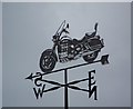
Weather vane, Winterborne Whitechurch
For centuries weathervanes have kept people in touch with the elements, signalling those shifts in the wind, which bring changes in the weather. This simple device has grown into an English tradition which can say something about their owners, adding interest to the landscape.
Image: © Maigheach-gheal
Taken: 1 Mar 2008
0.12 miles
7
Whatcombe lane, Winterborne Whitechurch
Image: © Alex McGregor
Taken: 18 Aug 2012
0.14 miles
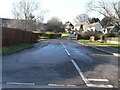
8
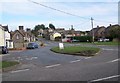
Street Scene, Winterborne Whitechurch
The minor road meets the A354 Salisbury to Dorchester Road. The village name appears in early records as Winterborne Blaunchminster. Winterborne stems from the river which starts to flow through the village during the winter months and continues until early summer. The word Whitechurch may come from the colour of the church or the chalky hills near it.
Image: © Maigheach-gheal
Taken: 1 Mar 2008
0.14 miles
9
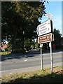
Winterborne Whitechurch: up Whatcombe Lane
Whatcombe Lane leads up to the higher three Winterborne villages of Clenston, Stickland and Houghton. On top of the modern signpost, the old finger-post finial, giving location and grid reference, has been retained.
For a close-up of the finial, see Image
Image: © Chris Downer
Taken: 21 Sep 2008
0.14 miles
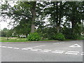
10
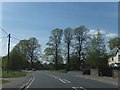
Lay-by at the centre of Winterborne Whitchurch
Image: © David Smith
Taken: 3 May 2014
0.15 miles