IMAGES TAKEN NEAR TO
Whatcombe, BLANDFORD FORUM, DT11 0PA
Introduction
This page details the photographs taken nearby to DT11 0PA by members of the Geograph project.
The Geograph project started in 2005 with the aim of publishing, organising and preserving representative images for every square kilometre of Great Britain, Ireland and the Isle of Man.

There are currently over 7.5m images from over14,400 individuals and you can help contribute to the project by visiting https://www.geograph.org.uk
Image Map
Images are licensed for reuse under creativecommons.org/licenses/by-sa/2.0
Notes
- Clicking on the map will re-center to the selected point.
- The higher the marker number, the further away the image location is from the centre of the postcode.
Image Listing (6 Images Found)
Images are licensed for reuse under creativecommons.org/licenses/by-sa/2.0
Image
Details
Distance
1
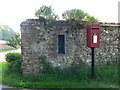
Whatcombe: postbox № DT11 42
I don't know how the one in the wall came to be damaged, but it has been replaced by a modern box on a pole.
Image: © Chris Downer
Taken: 21 Sep 2008
0.12 miles
2

View towards The Plantation and Stone Pits
Both the items mentioned are the wooded areas in the background.
Image: © Toby
Taken: 5 May 2007
0.20 miles
3
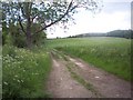
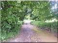
Footpath to Higher Whatcombe
The path runs parallel with the narrow road.
Image: © Maigheach-gheal
Taken: 29 May 2007
0.21 miles
4
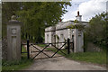
Lodge at entrance to Whatcombe House
The main entrance is further back on the road from Winterborne Whitechurch
Image: © John Lamper
Taken: 7 May 2006
0.22 miles
5
Higher Whatcombe
View west along the track leading west from Higher Whatcombe towards Whatcombe Common and Cliff Woods.
Image: © Nigel Mykura
Taken: 16 Jan 2010
0.23 miles
6
Footpath to the Keepers Cottage, Lower Whatcombe
Image: © Maigheach-gheal
Taken: 29 May 2007
0.25 miles