IMAGES TAKEN NEAR TO
Clenston Road, BLANDFORD FORUM, DT11 0NP
Introduction
This page details the photographs taken nearby to Clenston Road, DT11 0NP by members of the Geograph project.
The Geograph project started in 2005 with the aim of publishing, organising and preserving representative images for every square kilometre of Great Britain, Ireland and the Isle of Man.

There are currently over 7.5m images from over14,400 individuals and you can help contribute to the project by visiting https://www.geograph.org.uk
Image Map
Images are licensed for reuse under creativecommons.org/licenses/by-sa/2.0
Notes
- Clicking on the map will re-center to the selected point.
- The higher the marker number, the further away the image location is from the centre of the postcode.
Image Listing (4 Images Found)
Images are licensed for reuse under creativecommons.org/licenses/by-sa/2.0
Image
Details
Distance
1
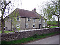
Quarleston Farm
This is the oldest building in Winterborne Stickland, dating from the 15th century in parts and was the home of the Quarrel family. For a number of years it was in a neglected state and occupied by squatters. The area has now been developed with a number of up-market properties on the site, which is now known as Quarleston Hamlet
Image: © John Lamper
Taken: 2 May 2006
0.07 miles
2
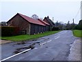
House at Winterborne Clenston
This is the view north along the main street that runs through Winterborne Clenston. The house on the left is known as The Old Tithe.
Image: © Nigel Mykura
Taken: 16 Jan 2010
0.19 miles
3
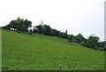
Bank near Canada Farm
This area used for clay pigeon shooting.
Image: © Toby
Taken: 6 May 2007
0.24 miles
4
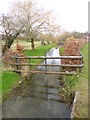
Winterborne Clenston, River Winterborne
Looking upstream. One of two Dorset rivers bearing this name, this is the North Winterborne. Winterbournes flow in winter, fed by aquifers, and often dry out in summer. http://www.england-in-particular.info/stour/s-winterborne.html
Image: © Mike Faherty
Taken: 1 Mar 2013
0.24 miles