IMAGES TAKEN NEAR TO
Milton Road, BLANDFORD FORUM, DT11 0LA
Introduction
This page details the photographs taken nearby to Milton Road, DT11 0LA by members of the Geograph project.
The Geograph project started in 2005 with the aim of publishing, organising and preserving representative images for every square kilometre of Great Britain, Ireland and the Isle of Man.

There are currently over 7.5m images from over14,400 individuals and you can help contribute to the project by visiting https://www.geograph.org.uk
Image Map
Images are licensed for reuse under creativecommons.org/licenses/by-sa/2.0
Notes
- Clicking on the map will re-center to the selected point.
- The higher the marker number, the further away the image location is from the centre of the postcode.
Image Listing (2 Images Found)
Images are licensed for reuse under creativecommons.org/licenses/by-sa/2.0
Image
Details
Distance
1
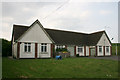
Milborne St Andrew Pumping Station
This is the last building in the village as you go out on the Milton Abbas road.
Image: © Marilyn Peddle
Taken: 30 Apr 2007
0.03 miles
2
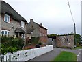
Coles Lane
This shows the junction of Coles Lane which goes off on the left, with the Milton Rd running through the village.
Image: © Nigel Mykura
Taken: 11 Oct 2009
0.06 miles