IMAGES TAKEN NEAR TO
Belchalwell, BLANDFORD FORUM, DT11 0EQ
Introduction
This page details the photographs taken nearby to DT11 0EQ by members of the Geograph project.
The Geograph project started in 2005 with the aim of publishing, organising and preserving representative images for every square kilometre of Great Britain, Ireland and the Isle of Man.

There are currently over 7.5m images from over14,400 individuals and you can help contribute to the project by visiting https://www.geograph.org.uk
Image Map
Images are licensed for reuse under creativecommons.org/licenses/by-sa/2.0
Notes
- Clicking on the map will re-center to the selected point.
- The higher the marker number, the further away the image location is from the centre of the postcode.
Image Listing (47 Images Found)
Images are licensed for reuse under creativecommons.org/licenses/by-sa/2.0
Image
Details
Distance
1
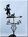
Weather vane, Belchalwell
Weather vanes have always been more than just a wind direction device. Created by skilled craftsman, there is true artistic expression in the varied designs. Initially wood vanes were carved by carpenters or furniture makers, and iron, copper and tin ones were forged by the local blacksmith or tinsmith. In the 19th century weather vanes started to be mass-produced from moulds.
Image: © Maigheach-gheal
Taken: 15 May 2010
0.05 miles
2
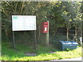
Belchalwell: postbox № DT11 165 and noticeboard
The postbox and noticeboard, by the corner of the lane to the church.
Image: © Chris Downer
Taken: 21 Sep 2008
0.06 miles
3
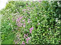
Pink campion, Belchalwell
Beside the track to St Aldhelm's Church wildflowers grow in abundance including campion. This untidy plant is commonly found in hedges, woods and shady places, which it brightens with a mass of carmine flowers in May and June.
Image: © Maigheach-gheal
Taken: 15 May 2010
0.10 miles
4
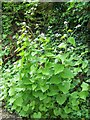
Jack by the hedge (Alliaria petiolata), Belchalwell
Beside the track to St Aldhelm's Church wildflowers grow in abundance including Jack by the hedge. It is also known as garlic mustard, which describes the aroma of the crushed leaves. This biennial plant grows to 1 metre tall in large groups below hedges and walls. After flowering from April to June, long seed pods are produced.
Image: © Maigheach-gheal
Taken: 15 May 2010
0.10 miles
5
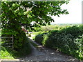
Path from St Aldhelm's, Belchalwell down to the village
Image: © Basher Eyre
Taken: 22 May 2010
0.11 miles
6
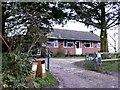
Cottage near Belchalwell
This cottage had blackboards outside it advertising eggs for sale and one or two other bits of farming produce.
Image: © Nigel Mykura
Taken: 2 Jan 2013
0.12 miles
7
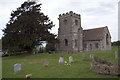
Belchalwell Church
The Church of St. Aldhelm overlooks Lower Belchalwell from a low hill to the north west to the village and portions around the Main doorway and south west facing side are believed to date from around 1190.
http://www.belchalwell.org.uk/church.asp
Image: © John Lamper
Taken: 7 May 2006
0.14 miles
8
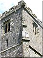
Sundial and tower, St Aldhelm's Church
Sundial on the church tower. The tower dates from the 15th century
Sundials or sun clocks are considered to be the oldest known device for the measurement of time and one of the most ancient scientific instruments.
The oldest known true sundial was built around 1500BC in Egypt. Shaped like a letter 'L' the length of the shadow cast by the vertical leg along the horizontal leg indicated the time. The Romans perfected the horizontal sundial we know today and invented portable travelling versions.
Image: © Maigheach-gheal
Taken: 15 May 2010
0.14 miles
9
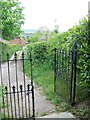
Through the gate, St Aldhelm's Church
Access to the church is gained via a track. There is a small parking area to the left.
Image: © Maigheach-gheal
Taken: 15 May 2010
0.14 miles
10
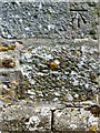
Bench Mark, St Aldhelm's Church
The bench mark is to be found on Image and http://www.bench-marks.org.uk/bm34392
A bench mark is an Ordnance Survey arrowhead sign found on walls, bridges, churches and specially erected triangulation pillars where the altitude above sea-level has been accurately measured by surveyors. The arrowhead points to a horizontal line above it which marks the exact altitude.
With rivets and pivots there is no datum (horizontal line) cut, the pointed-to horizontal surface defining the datum height.
Image: © Maigheach-gheal
Taken: 15 May 2010
0.14 miles