IMAGES TAKEN NEAR TO
Stalbridge, STURMINSTER NEWTON, DT10 2RT
Introduction
This page details the photographs taken nearby to DT10 2RT by members of the Geograph project.
The Geograph project started in 2005 with the aim of publishing, organising and preserving representative images for every square kilometre of Great Britain, Ireland and the Isle of Man.

There are currently over 7.5m images from over14,400 individuals and you can help contribute to the project by visiting https://www.geograph.org.uk
Image Map
Images are licensed for reuse under creativecommons.org/licenses/by-sa/2.0
Notes
- Clicking on the map will re-center to the selected point.
- The higher the marker number, the further away the image location is from the centre of the postcode.
Image Listing (2 Images Found)
Images are licensed for reuse under creativecommons.org/licenses/by-sa/2.0
Image
Details
Distance
1
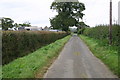
Approaching Triangle Farm
Approaching Triangle Farm situated at the corner of a triangle of roads
Image: © Shaun Ferguson
Taken: 19 Sep 2007
0.07 miles
2
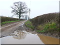
Station Road
This wet and muddy road runs east from Stalbridge to Triangle Farm. This large puddle is at the junction with a farm track that runs south to some fields.
Image: © Nigel Mykura
Taken: 20 Feb 2013
0.16 miles