IMAGES TAKEN NEAR TO
Ridge View, STURMINSTER NEWTON, DT10 2QJ
Introduction
This page details the photographs taken nearby to Ridge View, DT10 2QJ by members of the Geograph project.
The Geograph project started in 2005 with the aim of publishing, organising and preserving representative images for every square kilometre of Great Britain, Ireland and the Isle of Man.

There are currently over 7.5m images from over14,400 individuals and you can help contribute to the project by visiting https://www.geograph.org.uk
Image Map (Loading...)


Getting Data...Please wait
Leaflet Map data © OpenStreetMap
Images are licensed for reuse under creativecommons.org/licenses/by-sa/2.0
Notes
- Clicking on the map will re-center to the selected point.
- The higher the marker number, the further away the image location is from the centre of the postcode.
Image Listing (13 Images Found)
Images are licensed for reuse under creativecommons.org/licenses/by-sa/2.0
Image
Details
Distance
3
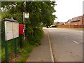
Lydlinch: postbox № DT10 97
Looking along the A357 past this postbox, which has been moved here in recent years, having previously been outside the old post office (closed 1987) and filling station when they were knocked down and the site redeveloped.
The box is emptied at 4:45 on weekday afternoons and at 10:30 on Saturday mornings.
Image: © Chris Downer
Taken: 23 May 2009
0.07 miles
4
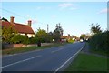
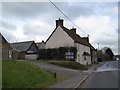
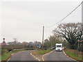
Lydlinch Dorset
Looking east into the village along the A357
Image: © Nigel Mykura
Taken: 22 Oct 2008
0.13 miles
5
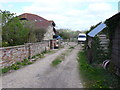
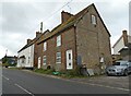
Footpath? What footpath?
This gives every appearance of being someone's yard with lots of vehicles and dogs running round. There are no footpath signs, and no footpath markers (until you get to the other side of the yard).
Image: © Nigel Mykura
Taken: 3 May 2013
0.22 miles
7

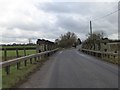
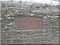
Plaque on Two Fords Bridge
Plaque placed in 1994 to commemorate the 50th anniversary of the building of the bridge Image by Canadian servicemen, to allow tanks over the River Lydden.
Image: © John Palmer
Taken: 30 Aug 2009
0.23 miles
9

Commemorative stone, Lydlinch
This stone records the planting of an oak tree in the centre of the village by Mrs Yeatman Biggs on September 9th 1902. The stone has been badly damaged at some time
Image: © Nigel Mykura
Taken: 22 Oct 2008
0.23 miles
10
Old Bridge Marker on Twofords Bridge, by the A357, Lydlinch Parish
Bridge Marker by the A357, in parish of Lydlinch (West Dorset District), Twofords Bridge, on old (Southern) carriageway, centre of North parapet.
Inscription reads:- : DORSET / ANY PERSON WILFULLY INJURING / ANY PART OF THIS COUNTY BRIDGE / WILL BE GUILTY OF FELONY AND / UPON CONVICTION LIABLE TO BE / TRANSPORTED FOR LIFE / BY THE COURT / 7 & 8 GEO 4 (? ?) T FOOKS :
Surveyed
Milestone Society National ID: DO_TRATWFbr.
Image: © Milestone Society
Taken: Unknown
0.24 miles