IMAGES TAKEN NEAR TO
New Road, STURMINSTER NEWTON, DT10 2PE
Introduction
This page details the photographs taken nearby to New Road, DT10 2PE by members of the Geograph project.
The Geograph project started in 2005 with the aim of publishing, organising and preserving representative images for every square kilometre of Great Britain, Ireland and the Isle of Man.

There are currently over 7.5m images from over14,400 individuals and you can help contribute to the project by visiting https://www.geograph.org.uk
Image Map (Loading...)


Getting Data...Please wait
Leaflet Map data © OpenStreetMap
Images are licensed for reuse under creativecommons.org/licenses/by-sa/2.0
Notes
- Clicking on the map will re-center to the selected point.
- The higher the marker number, the further away the image location is from the centre of the postcode.
Image Listing (24 Images Found)
Images are licensed for reuse under creativecommons.org/licenses/by-sa/2.0
Image
Details
Distance
1
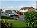
Stalbridge: postbox № DT10 173, Blackmore Road
Looking from Robinson Heights across the garden of the house on the corner. The Elizabeth II-reign postbox is emptied finally at 4:30pm on weekdays and at 9:15am on Saturdays.
Image: © Chris Downer
Taken: 8 Aug 2009
0.11 miles
2
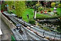
Garden Railway, Stalbridge
I came across the model railway by chance in a back garden in Stalbridge. The owner had built all the track, locos and rolling stock himself in absolutely beautiful detail. He had also built a large number of other models in a wide variety of scales. These included fully working trains and fairground rides mostly in wood but all with superb engineering skill and an absolutely immaculate detailed finish. I was privileged to be shown some of his work.
Image: © Nigel Mykura
Taken: 14 Oct 2008
0.12 miles
3
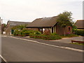
Stalbridge: the library
A modern and small library serving Stalbridge and local villages.
Image: © Chris Downer
Taken: 23 May 2009
0.16 miles
4
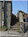
The path out of the village
Follow this footpath and you can get to the school or carry on towards Drew's Lane or Shipney Lane.
Image: © Neil Owen
Taken: 7 Jun 2023
0.17 miles
5
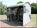
Shaking up milk sales
A stand-alone milk station in Stalbridge, close to the car park on Station Road. It is a self-service unit offering fresh cooled milk, dairy products and milkshakes. The latter has the small side shelf with a corrugated canopy over it, with several pump dispensers containing various flavoured syrups.
Image: © Neil Owen
Taken: 7 Jun 2023
0.18 miles
6
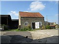
The Gugg
Formerly Guggleton Farm, the site now also offers residence for several small businesses, workshops and an arts hub.
Image: © Neil Owen
Taken: 7 Jun 2023
0.18 miles
7
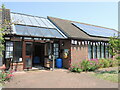
Stalbridge library and The Hub
A modern building by the car park that offers a community room for hire next to the library. An obligatory defribrillator in a round case resides by the door.
Image: © Neil Owen
Taken: 7 Jun 2023
0.19 miles
8
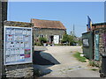
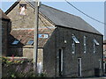
Guggleton Gallery Stalbridge
The Guggleton Gallery is housed in an old building in a former farmyard set back off Station Road.
Image: © Sarah Smith
Taken: 10 Sep 2014
0.19 miles
9
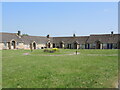
Open space in Stalbridge Close
The retirement homes have a small floral display in the open space to view.
Image: © Neil Owen
Taken: 7 Jun 2023
0.20 miles
10
A guard dog for The Gugg?
An image high in the end wall window of a farm building seems to have been changed from a previous occupant.
Image: © Neil Owen
Taken: 7 Jun 2023
0.20 miles