IMAGES TAKEN NEAR TO
Stalbridge Close, STURMINSTER NEWTON, DT10 2ND
Introduction
This page details the photographs taken nearby to Stalbridge Close, DT10 2ND by members of the Geograph project.
The Geograph project started in 2005 with the aim of publishing, organising and preserving representative images for every square kilometre of Great Britain, Ireland and the Isle of Man.

There are currently over 7.5m images from over14,400 individuals and you can help contribute to the project by visiting https://www.geograph.org.uk
Image Map
Images are licensed for reuse under creativecommons.org/licenses/by-sa/2.0
Notes
- Clicking on the map will re-center to the selected point.
- The higher the marker number, the further away the image location is from the centre of the postcode.
Image Listing (85 Images Found)
Images are licensed for reuse under creativecommons.org/licenses/by-sa/2.0
Image
Details
Distance
1
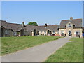
Stalbridge Close
A retirement housing complex set around a formal grass square.
Image: © Neil Owen
Taken: 7 Jun 2023
0.01 miles
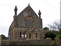
2
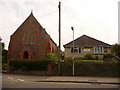
Stalbridge: Congregational Church dental surgery
A simple red-brick chapel alongside what is now the dentist's in Stalbridge.
Image: © Chris Downer
Taken: 23 May 2009
0.02 miles
3
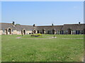
Open space in Stalbridge Close
The retirement homes have a small floral display in the open space to view.
Image: © Neil Owen
Taken: 7 Jun 2023
0.04 miles
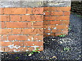
4
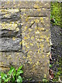
Bench Mark, Methodist Chapel
The bench mark is to be found on the south west face of the chapel. For a wider view of the chapel Image and for further information on the bench mark and others in the area http://www.bench-marks.org.uk/bm36444
Image: © Maigheach-gheal
Taken: 4 Jan 2011
0.05 miles
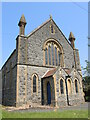
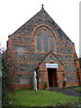
5
Methodist Chapel, Stalbridge
The chapel is on Ring Street. There is an Ordnance Survey bench mark on the south west face.
Image: © Maigheach-gheal
Taken: 4 Jan 2011
0.05 miles
6
Former Methodist church on Stalbridge High Street
Now a private residence from about 2013, the old building has a benchmark on it - see Image
Image: © Neil Owen
Taken: 7 Jun 2023
0.05 miles
7
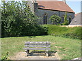
A seat on Stalbridge Close
A small corner plot (perhaps the site of a former house?) on the junction with the A357 main road offers a seat.
Image: © Neil Owen
Taken: 7 Jun 2023
0.05 miles
8
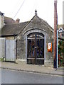
Pump house, Stalbridge
The pump house dates from 1885 and is built of coursed rubble and stone. It was being used to house a tableau of the Nativity.
Image: © Maigheach-gheal
Taken: 4 Jan 2011
0.05 miles
9
Bench Mark, Congregational Chapel
The bench mark is on the west angle of the church. For a wider view Image and for further information on the bench mark and others in the area http://www.bench-marks.org.uk/bm36445
Image: © Maigheach-gheal
Taken: 4 Jan 2011
0.05 miles
10
Congregational Chapel, Stalbridge
There is an Ordnance Survey bench mark on the west angle of the building.
Image: © Maigheach-gheal
Taken: 4 Jan 2011
0.05 miles