IMAGES TAKEN NEAR TO
Stourton Caundle, STURMINSTER NEWTON, DT10 2JJ
Introduction
This page details the photographs taken nearby to DT10 2JJ by members of the Geograph project.
The Geograph project started in 2005 with the aim of publishing, organising and preserving representative images for every square kilometre of Great Britain, Ireland and the Isle of Man.

There are currently over 7.5m images from over14,400 individuals and you can help contribute to the project by visiting https://www.geograph.org.uk
Image Map (6 Images)


Getting Data...Please wait
Leaflet Map data © OpenStreetMap
Images are licensed for reuse under creativecommons.org/licenses/by-sa/2.0
Notes
- Clicking on the map will re-center to the selected point.
- The higher the marker number, the further away the image location is from the centre of the postcode.
Image Listing (6 Images Found)
Images are licensed for reuse under creativecommons.org/licenses/by-sa/2.0
Image
Details
Distance
2
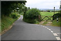
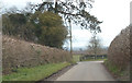
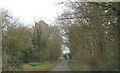
Road down to Stourton Caundle
Junction of Rue Lane and road down to Stourton Caundle
Image: © Shaun Ferguson
Taken: 19 Sep 2007
0.05 miles
3
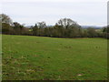
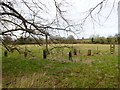
Pasture Fields near Stourton Caundle
The area round Stourton is quite undulating and most of the sloping fields are pasture such as this one.
Image: © Nigel Mykura
Taken: 20 Feb 2012
0.06 miles
6
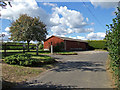
Tree Barrier near Haddon Lodge
A 20 metre strip along the road has been planted with new trees, presumably to screen Haddon Lodge from the road or vice versa or both.
Image: © Nigel Mykura
Taken: 20 Feb 2012
0.25 miles